Ten of the Biggest and Best Geoglyphs from the Ancient World
The most well-known geoglyphs in the world are undoubtedly the Nazca Lines of coastal Peru. Yet, scattered across the globe are thousands of other geoglyphs that are equally as impressive. The earth carvings remain one of archaeology’s greatest mysteries. Despite a plethora of research on these amazing creations, the purpose of geoglyphs continues to elude researchers and remains a matter of conjecture. Some scientists believe they are linked to the heavens, representing constellations in the night sky. Other experts believe that the lines played a role in pilgrimage, with one walking across them to reach a sacred place. Yet another idea is that the lines are connected with water, something vital to life yet hard to get in the desert. Here we examine ten alluring geoglyphs from across the planet.
The Enigmatic Nazca Lines of Peru

Aerial view of the Nazca Lines Owlman (astronaut), Peru. ( Cezary Wojtkowski /Adobe Stock)
Located in the arid Peruvian coastal plain, some 400 km south of Lima, the geoglyphs of Nazca cover an incredible 450 km2. They are among archaeology's greatest enigmas because of their quantity, nature, size and continuity. The geoglyphs depict living creatures, stylized plants and imaginary beings, as well as geometric figures several kilometers long.
The startling feature of the Nazca geoglyphs is that they can only really be appreciated from the air, raising questions about how and why they were created. The Nazca lines number in their thousands and the vast majority of them date from 200 BC to 500 AD, a time when a people referred to as the Nazca inhabited the region. The earliest lines, created with piled up stones, date as far back as 500 BC.
Although the lines can in fact be seen from the ground, there is nothing remotely exciting about seeing them from this perspective. However, from the air, their true beauty and the wonders of their creation can be realized.
Despite a plethora of research on these amazing creations, the purpose of the lines continues to elude researchers and remains a matter of conjecture. Some scientists believe they are linked to the heavens with some representing constellations in the night sky. However, research has found that there are just as many lines not related to constellations as those that are, meaning that this theory cannot provide a complete explanation.
Other experts believe that the lines played a role in pilgrimage, with one walking across them to reach a sacred place such as Cahuachi and its adobe pyramids. Yet another idea is that the lines are connected with water, something vital to life yet hard to get in the desert, and may have played a part in water-based rituals. However, the fact the lines have remained enigmatic have promoted alternative theorists to float ideas about extraterrestrial communication or ‘messages to the gods’.
The Puzzling Case of the Atacama Giant

The Atacama Giant (CC BY-SA 2.0) with superimposed outline sketch of the geoglyph (Public Domain)
The geoglyphs of the Atacama Desert in South America are less familiar than the world-renowned Nazca lines, yet they are far more numerous in number, more varied in style, and cover a much larger area.
One of the most intriguing and controversial aspects of the Atacama desert geoglyphs is the so-called Atacama Giant, which continues to stir debate regarding its true meaning and interpretation. The Atacama Giant is an anthropomorphic geoglyph measuring 119 meters (390 feet) in height, making it the largest known geoglyph in the world.
It is characterized by a square head and highly stylized long legs. Four lines can be seen coming out from the top of the giant’s head, as well as on each side of its head. There has been no shortage of explanations and theories to account for the strange features of this enormous geoglyph. According to one interpretation, it was a sort of astronomical calendar that indicated the movement of the Moon.
With this knowledge, it is said that the day, the crop cycle, and the seasons could be calculated. Another interpretation maintains that the Atacama Giant represents a deity worshipped by the local population.
Other theories suggest extra-terrestrial visitations, marking of a pilgrimage route, or that it reflects an ancient type of language. Although the function of the geoglyphs of the Atacama Desert still remain a mystery, it is undeniable that they held great importance to the people who lived in the region. It is hoped that the geoglyphs will be preserved for future generations, and that further research may one day uncover their secrets.
Over 50 Ancient Geoglyphs, Including Swastika, Discovered in Kazakhstan

More than 50 geoglyphs have been discovered in northern Kazakhstan. Many of them are made of earthen mounds (although timber was used to make this swastika). (Image copyright DigitalGlobe, courtesy Google Earth)
Archaeologists are calling them the Nazca lines of Kazakhstan – more than 50 giant geoglyphs formed with earthen mounds and timber found stretched across the landscape in northern Kazakhstan.
They are designed in a variety of geometric shapes, including crosses, squares, rings, and even a swastika, an ancient symbol that has been in use for at least 12,000 years.
The geoglyphs, which are very difficult to see on the ground, were first spotted on Google Earth. Since then, a team of archaeologists from Kazakhstan and Lithuania, have investigated the giant structures using aerial photography and ground-penetrating radar. Their results revealed a wide variety of shapes ranging from 90 to 400 meters (295 to 1300 feet) in diameter, mostly made of earthen mounds, but one – the swastika – was made using timber.
Researchers have not yet dated the structures but their characteristics suggest they are around 2,000 years old. "As of today, we can say only one thing — the geoglyphs were built by ancient people. By whom and for what purpose, remains a mystery," said archaeologists Irina Shevnina and Andrew Logvin, of Kostanay University, in an email to Live Science.
Ancient Rock Lines Created by Enigmatic Paracas Culture Predate Nazca geoglyphs

A view of two rock lines that mark the June solstice with a person for scale. (Charles Stanish / Live Science)
A study published in the journal Proceedings of the National Academy of Sciences, revealed the discovery of a complex set of geoglyphs constructed by the mysterious Paracas people of Peru. The archaeological features, which date back 2,300 years, were found to be aligned to the sunset during the winter solstice, and are believed to have been created to mark ceremonial mounds and residential sites.
Charles Stanish, the director of the Cotsen Institute of Archaeology at the University of California, and his team, found 71 geoglyph lines or segments, 353 rock cairns, rocks forming circles or rectangles, two U-shaped mounds, and one point at which a series of lines converged in a circle of rays.
Many of the archaeological features were found to have astronomical alignments, others point to special places in the landscape, like some of the ancient pyramids in the region. The research team hypothesized that the lines served diverse purposes – some appear to have marked time, others may have attracted participants to attend important events, and yet others could have pointed the way to sacred structures.
The ‘Works of Old Men’: Geoglyphs of the Middle East

Ancient geoglyphs of the Middle East ( clusterflock)
Stretching from Syria to Saudi Arabia, thousands of ancient geoglyphs built from stone stretch across the desert plains. Known as the “works of old men”, some display a kite-like structure while others have wheel-like designs. Similar to the Nazca Lines of Peru, they come in a wide variety of shapes and sizes, with much diversity between structures. The geoglyphs are virtually invisible to those on the ground, but can be easily discerned by those flying overhead. The local Bedouins refer to them as the “works of old men” but have been unable to provide further insights into their creators.
Some of the circular structures contain two spokes that form a bar pointing in the same direction in which the Sun rises and sets, while others contain spokes that do not appear to have any astrological meaning. It is believed that one type of structure, referred to as a “kite”, was actually used as part of a system for hunting. The long stone walls form a wide open area, which then funnels into a smaller, enclosed area. Wild animals would funnel from the larger area through the neck into the narrow area which was called the “killing floor.” This would make it easier to hunt wild animals, as their movement would be constricted once they reached the killing floor. There are an estimated 2000 kite structures across the deserts of Syria, Jordan, Southern Israel and Saudi Arabia illustrating that this hunting method must have been widely used.
Wari Geoglyph Similar to Nazca Lines Found in Peru

The newly discovered geoglyph in Arequipa. (Peru21)
Archaeologists recently carrying out excavations in Arequipa in southern Peru were surprised to find a large geoglyph which resembles the famous Nazca lines. The massive geoglyph is the first of its kind discovered in the region. It has been linked to the pre-Inca Wari culture (1200-1300 AD), although it is not clear how the researchers reached this conclusion.
The geoglyph, which measures 60 meters (197 feet) by 40 meters (131 feet) consists of a large rectangular image with geometric shapes and lines within it. If indeed the newly discovered geoglyph was created by the Wari people, the finding may serve to shed new light on their cultural practices, which could have been influenced by the Nazca people.
The Wari (Spanish: Huari) civilization flourished from about 600 AD in the Andean highlands and forged a complex society widely regarded today as ancient Peru’s first empire. Their Andean capital, Huari, became one of the world's great cities of the time. Relatively little is known about the Wari because no written record remains, although thousands of archaeological sites reveal something about their lives.
Children Helped Build Mysterious 6,000-year-old Moose Geoglyph in Russia

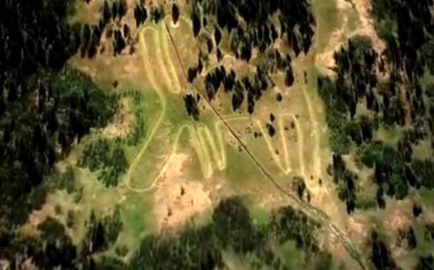
Moose geoglyph in Ural Mountains, Russia. Picture: Stanislav Grigoryev
Recent research revealed that an enormous geoglyph of a moose in the Ural Mountains, Russia, is among the oldest examples of land art in the world, dating back some 6,000 years. The moose measures approximately 275 meters (900 feet) in length (at its longest point) and was formed by ditches 30 centimeters (12 inches) deep and between 4.5 meters (15 feet) and 10 meters (32 feet) wide. The ditches were dug out and then filled with stones, with larger stones usually placed along the edges and smaller stones used to fill in the middle. The hooves of the moose were filled in with a mixture of clay and crushed stones. An analysis of stone tools found at the site revealed a style of lithic reduction that corresponds to the period between 3,000 and 4,000 BC.
Perhaps one of the most interesting discoveries to emerge from recent excavation work at the site, is that an examination of more than 150 tools found around the geoglyph suggests that children were involved in its construction, as well as adults. “But it was not a kind of slave labor of children,” said Stanislav Grigoryev, a senior researcher from the Chelyabinsk History and Archaeology Institute, “They were involved to share common values, to join something important to all the people.”
Giant Stone Circles in the Middle East Puzzle Archaeologists

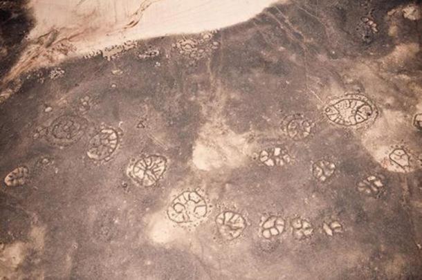
Mysterious Big Circle, Archaeology of the Middle East. (APAAME)
Huge stone circles in the Middle East have been imaged from the air, but researchers remain puzzled as to why they exist, and who made them. Eleven big circles dot the landscape across Jordan and Syria. They date back at least 2,000 years, but may even be pre-historic, created in a time before the invention of writing.
The geoglyphs are very large, some of them approximately 1,300 feet in diameter, and are composed of short, stone walls built from local rocks. Researchers say the circles would have required some planning, as many of the circles are very precise. It was likely there was some sort of “architect” to head up each project.
Researchers question whether the circles were used to maintain animal herds, or may have been areas of burial, but so far no contemporary remains or any obvious practical uses have been recovered or gleaned from the sites.
Thousands of other ancient structures have been found across the Middle East, such as wheels, walls, pendants (lines to and from burial cairns) and kites (stone walls used to drive animals into kill areas). Much like the enigmatic Nasca lines of Peru - giant geoglyphs half a world away from Jordan - the intentions of the builders, and the purpose of the designs remain, for now, a very baffling mystery.
The Unknown Origins of the Incredible Sajama Lines of Bolivia

The Sajama Lines, Bolivia (Bolivian Government / List of Wonders)
In Western Bolivia, thousands and thousands of perfectly straight paths are etched into the ground, creating an amazing sight. These lines were carved into the ground over a period of 3,000 years by indigenous people living near the volcano Sajama. It is unknown exactly when or why they were constructed, and it is hard to imagine how the construction of something of such magnitude could pre-date modern technology.
The Sajama lines cover an area of approximately 22,525 square kilometers, or 8,700 square miles. They are perfectly straight lines, formed into a web or network. Each individual line is 1-3 meters, or 3-10 feet wide. The longest lines measure 20 kilometers, or 12 miles in length.
The creation of these lines without the aid of modern technology is a marvel. They were etched into the ground by scraping vegetation to the side, and scouring away dark surface material consisting of soil and oxidized rock, to reveal a light subsurface. The precision of the Sajama lines is remarkable. While many of these sacred lines extend as far as ten or twenty kilometers (and perhaps further), they all seem to maintain a remarkable straightness despite rugged topography and natural obstacles. Some believe that the indigenous people used the lines as a navigational tool during sacred pilgrimages. Wak'as (shrines), chullpas (burial towers) and hamlets are interspersed among the lines, creating a cultural landscape.
The Mysterious Prehistoric Geoglyph of the Paracas Candelabra

The Paracas Candelabra. (CC BY-SA 2.0)
The Paracas Candelabra is a prehistoric geoglyph found in the Paracas Peninsula at Pisco Bay, Peru. With a large, branchlike appearance, the purpose and meaning of the Candelabra remains unknown.
The Paracas Candelabra is estimated to be approximately 595 – 800 feet (181 – 244 meters) tall and can be seen from as far as 12 miles (19km) out at sea. The geoglyph was created by cutting two feet deep into the hardened soil, with rocks placed around the figure.
The shape of the geoglyph is mysterious and somewhat difficult to describe. Some have likened it to a cactus plant, while others believe it looks more like a three-branched candlestick, hence the name “candelabra.”
The meaning and purpose of the Paracas Candelabra are unknown to this day. The Conquistadors supposedly believed the geoglyph represents the Holy Trinity, and took it as a good omen and a sign that they should proceed with their quest to conquer and Christianize the locals, although no clear historical records authenticate this assertion.
Some believe the Paracas Candelabra is a representation of a hallucinogenic plant called Jimson weed, while others have suggested that the geoglyph represents a lightning rod of the god Viracocha, who was the great creator god in the pre-Inca and Inca mythology in the Andes region of South America. The true meaning and purpose of the Paracas Candelabra remain elusive to this day, and may be forever lost to history. Nevertheless, the enormous geoglyph continues to attract people from all over the world who marvel at its sheer size and wonder about its origin and creation.
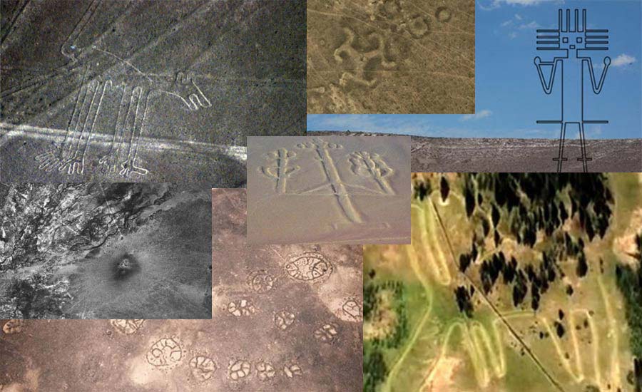
Top image: Montage of article images. Source: Various


Comments
There is also a geoglyph in Macedonia, of the ancient sun god Dze and mother goddess Mo. It is near the place called Sveti Nikole
https://www.academia.edu/5552841/The_Ancient_Giant_Geoglyph_in_Macedonia
Maybe it was an arrow of sorts.
Maybe the last one was an arrow of sorts.
People were REALLY bored and had a LOT of time on their hands back then. That the more creative of our ancestors would engage in such activities is no surprise to me.
It resembles something seen on very, very old cylinder seals from the Middle East IMO. Possibly a depiction of the "tree of life", yes.....
Pages