


The Enduring Mystery and Ancient Artistry of Bolivia’s Sajama Lines
When flying over the desert of the Altiplano plateau in western Bolivia, a fascinating sight awaits. Thousands of impeccably straight paths are etched into the ground of the Andean landscape, forming an intricate network of geoglyphs known as the Sajama Lines. They’ve even been described as the largest work of art in the world.
These enigmatic markings can be found within the confines of Sajama National Park—protected as a UNESCO World Heritage Site—and were painstakingly created over a span of 3,000 years by the indigenous people residing near the majestic extinct Sajama volcano. Experts remain puzzled by the origins and purpose of the Sajama geoglyphs, while their scale and precision continue to challenge our understanding of the technology and knowledge of ancient civilizations.

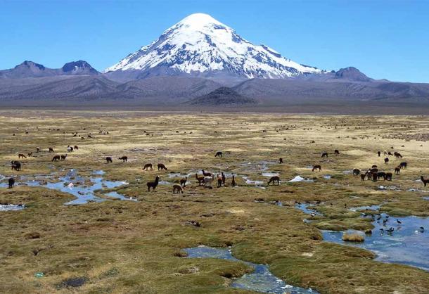
The Andean desert landscape at Sajama National Park, home to the mysterious Sajama Lines. (Florian / Adobe Stock)
Exploring the Magnitude and Purpose of the Sajama Lines
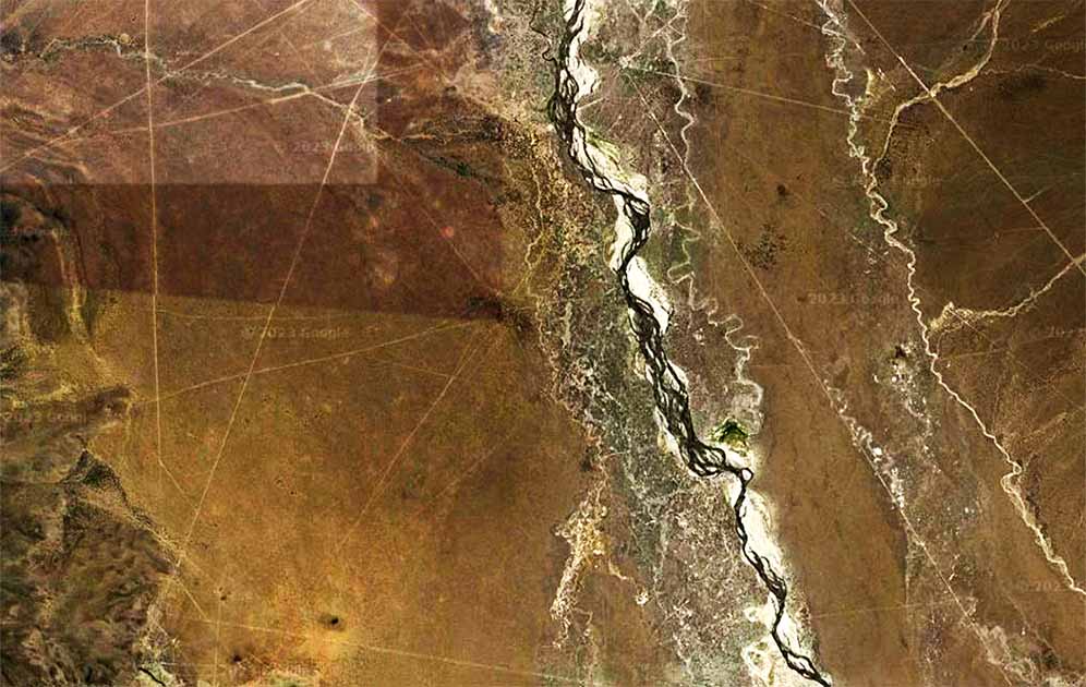
The Sajama Lines, stretching across a vast area of approximately 22,525 square kilometers (8,700 sq mi), form an intricate web of perfectly straight paths amidst the awe-inspiring landscape of Bolivia's Altiplano plateau. This expansive region is characterized by majestic snow-capped peaks, high-altitude plains and the resilient queñoa trees that dot the terrain. Ground-level exploration offers only a glimpse of the Sajama Lines' scale, but satellite imagery reveals the true magnitude of this ancient geoglyphic network.
- Ten of the Biggest and Best Geoglyphs from the Ancient World
- The Enigma of the Nazca Lines: Strange Theories and Unanswered Questions
When viewed from above, each individual line, measuring 1 to 3 meters (3 to 10 ft) in width, weaves seamlessly with others, resulting in an astonishing and intricate pattern. Remarkably, the longest lines extend up to an impressive length of 20 kilometers (12 mi), traversing the vast expanse of the Altiplano.
The construction of these lines stands as a testament to the ingenuity and resourcefulness of the ancient indigenous people who crafted them. Without the aid of modern tools or technology, they meticulously scraped aside the vegetation and scoured the dark surface material, which consisted of soil and oxidized rock. Through this careful process, they revealed the lighter subsurface, creating a striking contrast that gives the Sajama Lines their distinct appearance. The level of precision exhibited in their formation is a testament to the knowledge and skill possessed by these ancient civilizations.
Experts believe that the Sajama Lines were created thousands of years ago, by scraping aside the rough vegetation to expose the lighter subsurface beneath. (Léo Guellec / CC BY-SA 2.0)
Decoding the Purpose of Bolivia's Mysterious Sajama Lines
Much like the Nazca Lines of southern Peru, the purpose of the Sajama Lines remains a subject of speculation, particularly due to the lack of archaeological and historical research conducted in the area. But unlike Nazca, where there are both geometric lines and others that represent animals and anthropomorphic figures, the Sajama Lines are all straight as an arrow, cutting through the landscape like a knife. Their sheer precision and uniformity raise intriguing questions about the ancient techniques employed in their construction.
Some theories suggest that the Aymara people, who are believed to have created the Sajama Lines, used them as navigational aids for sacred pilgrimages. It is thought that these indigenous individuals would follow the straight paths of the lines as they embarked on significant spiritual journeys.
Among the network of lines, one can also find wak'as, which are shrines, chullpas, which are burial towers, and small hamlets, further enhancing the complex cultural landscape intertwined with the Bolivian Sajama Lines. A study by Adam Birge, suggested that these lines were likely created during pre-Hispanic times (before 1532), and that they possibly predated the Inca civilization. Intriguingly, Birge even proposes that the lines may still hold some contemporary ceremonial and navigational significance and they are still in use today.
The presence of the Sajama Lines stands as a testament to the ingenuity and skill of ancient civilizations, challenging our understanding of prehistoric technology and the cultural significance of vast geoglyphic networks. As researchers and explorers continue to delve into the mysteries embedded within Bolivia's Altiplano plateau, we inch closer to unraveling the secrets that lie beneath the surface, shedding light on the remarkable legacy of the Sajama Lines.
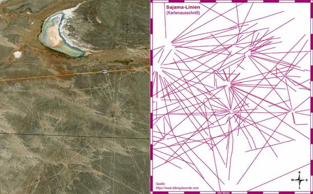
Left: Some of the Sajama Lines as seen from the air. (Google Earth) Right: Diagram of the Sajama Lines by the University of Pennsylvania. (Meister / CC BY-SA 3.0)
The Discovery, Preservation and Study of Bolivia's Sajama Lines
The Sajama Lines were first accounted for in the 1932 book Paseo de Tschiffely by traveler Aimé Felix Tschiffely, remembered for his epic horseback adventure from Buenos Aires in Argentina to New York in the United States in the 1920s. A few years later, anthropologist Alfred Metraux published ethnographic fieldwork about the Aymara and Chipaya people of the Carangas region, bringing the lines and cultural landscape to the attention of scholars.
During the 1970s, filmmaker Tony Morrison made significant contributions to the study of the lines by producing a documentary and authoring books. His groundbreaking work was the first to suggest a relationship between the lines and the surrounding peaks, proposing the idea of a pilgrimage complex. By highlighting this integration, Morrison offered fresh insights into the nature of the lines and their potential cultural significance, furthering our understanding of this intriguing phenomenon.
More recently, the Landmarks Foundation has worked to protect the lines from threats of erosion, unchecked development and tourism in the area, and other dangers that come from the absence of a management plan. They have studied the lines and created a database to help protect them.
Working closely with the University of Pennsylvania, the Landmarks Foundation also created the Tierra Sajama Project, utilizing analytic digital media tools such as geographic information systems (GIS) to map, describe and analyze the lines. The Tierra Sajama Project successfully fulfilled its goals by establishing a comprehensive computer database containing maps and essential details regarding the Sajama Lines, local vegetation and significant topography.
#ReadMore about the unknown origins of the incredible Sajama Lines of Bolivia http://t.co/F9AEVWH5GW pic.twitter.com/fab1aUWXEY
— Marcela Zapata-Meza (@Machezm) December 8, 2014
Through careful analysis, researchers deciphered patterns and meanings within the landscape, including alignments between mountaintop shrines and religious structures, shedding light on the potential significance of these sacred lines. Furthermore, the project formulated proposals aimed at ensuring the long-term preservation of the lines and fostering a deeper understanding and appreciation of the sacred landscape.
Unfortunately, the analytical mapping of the size, shape and location of the Sajama Lines doesn’t answer the many questions which remain, such as who created them, what was their purpose, and what tools did they use? Answering these questions may help us to understand another piece of human history. For now, we will have to continue to marvel at the vast area covered by the lines, and the amount of effort it must have taken to create them, without fully understanding their purpose or function.
Top image: The Sajama Lines in Bolivia, as seen by satellite imagery. Source: Google Maps
By M R Reese
References
Álvarez, J. 21 February 2017. “Las Líneas de Sajama, el Nazca boliviano” in La Brujula Verde. Available at: https://www.labrujulaverde.com/2017/02/las-lineas-de-sajama-el-nazca-boliviano
Birge, A. 2016. “Ritualized Memory and Landscape at Pueblo Sajama, Bolivia: A Study of a Sacred Landscape and Colonial Encounter” in The University of Texas at San Antonio.
Milligan, M. 25 November 2020. “The Mysterious Sajama Lines” in Heritage Daily. Available at: https://www.heritagedaily.com/2020/11/the-mysterious-sajama-lines/136230
Tschiffely, A. F. 1934. Tschiffely’s Ride. Heinemann.

Comments
maybe look at a 3 d image of the lines see which ones are a metre which ones are 2 metres 3 metres in width etc.and see what image it makes. lines 1 metre may be further away from lines that are 3 metre s wide. could do the same with Nazca lines creating a hologram picture of something
If your not sitting on your backside starring at the idiot tube or commuting you have time to do a lot of things. If you do them often you get better. I have fenced most of my 5 acres with just eyesight and most of the posts are within a few inches of very straight over 700 ft. For longer distances you set up waypoints to keep you lined up. The only thing hard about it today over the past is it's too much trouble to get it right.
I see two way of looking à those lines. First, the paterns remind me of old navigation map (like this one:

So could those lines represent a huge map of interesting places in the Earth? Or in the sky?
An other possibility. Has anyone considered those lines to be a calendar or in relation with the positions of the stars? For exemple, standing at one end of a line, looking in the direction of the line at a certain date/time in the year, the line would point to a star. Because some lines seems to start from the same origin, that place could be the viewpoint for those lines at a certain period. And other lines for other moments during the year.
I agree with you Chad!... It is a language in sign forms... mostly all ancient geoglyph(s) are.
Some very interesting ideas there. Are you suggesting that geoglyps such as the Sajama Lines are a type of communications attempt by ETs, or....?
Pages