


Tracking Artifacts Reveals Lost Nordic Mountain Trade Route
In pre-history, many of the world's mountain ranges blocked long distance travel and trade, but mountain passes provided routes through ranges and over ridges, facilitating human and animal migration, trade, and military conquests. With global warming rapidly melting glaciers across the planet, in 2011 Glacier Hub told how archaeologists in Norway discovered a “1,700-year-old tunic,” at the Lomseggen mountain in Breheimen National Park, after sun exposed the upper edges of Lendbreen Glacier.
Now, a new paper has been published in the journal Antiquity by researchers Lars Pilø, Espen Finstad, and James H. Barrett, from the Department of Cultural Heritage, Innlandet County Council in Norway, the University of Cambridge in England, and the Norwegian Department of Archaeology and Cultural History, NTNU University Museum, respectively. The report presents a range of ancient artifacts dating from between 300 and 1500 AD, which enables new conclusions regarding long distance Nordic mountain travel in ancient Europe.

Melting glacier has revealed the following artifacts related to clothing and daily life: A) goat or lamb bit?; B) knife; C) shoe; D) mitten; E) leaf-fodder; F) whisk and/or peg; G) distaff? (Glacier Archaeology Program & J. Wildhagen)
3000 Ancient Artifacts Recovered From Frozen Mountain Pass Revealed by Global Warming
In an email to Ancient Origins, researcher James H. Barrett said the new archaeological finds provide information concerning “the socio-economic factors that influenced high-elevation travel” and they also increase the understanding of how mountain passes affected “inter and intra-regional communication and exchange.”
- Hunters Find Striking Viking Sword Isolated at High Altitude in Norway
- Thawing Ice Reveals Norwegian Mountains Littered with Iron and Bronze Age Artifacts
- Surprises from the Ice: Ancient Arrowheads Found Via Melting Glaciers in Norway
Glacial archaeology is a relatively new discipline that has been developed to rescue ancient artifacts exposed by global warming. These artifacts offer information about ancient trends in high-elevation hunting, transhumance, and travel associated with social, economic, and ecological mechanisms, and Lars Pilø, the author of the new paper, says this new work is “uniquely important”.

Upper left) an object interpreted as a tong (a clamp for holding fodder on a sled or wagon) dated to the Late Roman Iron Age; right) a similar, undated object, also from the pass area; lower left) a historical example from Uppigard Garmo, pre-dating c. 1950. (Glacier Archaeology Program & R. Marstein)
Central Norway has yielded the largest number of glacial-locked artifacts and the Glacier Archaeology Program of Oppland County is a cooperation between Oppland County Council and the Museum of Cultural History, University of Oslo, that was set up after patches in Oppland became visible during the big melt in the fall of 2006. Since the 2011 discovery of the 1700-year-old tunic, the team has surveyed 51 ice patches, finding more than “3000 artifacts” including textiles, tools made from reindeer antlers and horse bones, and samples of horse dung. In the email to Ancient Origins, Lars Pilø said the pass area contains “other finds that predate the use of the pass,” both artifacts from hunting and natural materials such as a Neolithic bear skull, which is explored further on the team’s website, Secrets of the Ice.
100 Stone Cairns Mark the Ancient Nordic Mountain Route
The scientists say these 51 ice patches provide evidence of the region having functioned as an ancient mountain pass. In the area surrounding where the ancient tunic was found, archaeologists have discovered approximately 800 artifacts and 150 bones, 100 cairns, and the foundations of a stone-built shelter. Since 2011, it has become evident that the Lendbreen pass hosted long-distance travelers from the Roman Iron Age (between 1 - 400 AD) to the end of the Middle Ages (between 1050 - 1537 AD.)

Top: Aerial view of Lendbreen from the south-west; light-grey areas (without lichen) have seen recent ice-melt (photograph: L. Pilø). Bottom: Lendbreen from the north-east; arrows 1–3 indicate the locations of cairns visible on approach from Ottadalen; arrow 4 indicates the location of a stone-built shelter. (Image: J.H. Barrett).
Clusters of transport-related artifacts like wooded sleds, walking sticks, horseshoes, a woven mitten, and several shoes, have melted out of ice along this route and among the five mountain passes on Lomseggen only Lendbreen had a stone-built shelter. Situated near the top of this ice patch it identifies this particular pass as a route of “special significance” - which perhaps reflects hunting activity by individuals taking different paths up the ridge.
Alternatively, the scattered patches of archaeological finds might represent the “post-depositional spreading of lighter objects.” And while the stone cairns and remains of the building at Lendbreen cannot yet be dated, their locations mark a northern route through partly ice-covered slopes and down the southern face towards the Bøverdalen Valley.

Top: Examples of cairns marking the Lendbreen pass, numbered as in the previous image (photographs: J.H. Barrett). Bottom: Stone shelter near the top of the pass (Images: E. Finstad).
Regarding the time-depth of the site, scientist James H. Barrett said in his email to Ancient Origins that an arrow dated to 1374-1118 BC, and a wooden ski to around 600 BC were recovered, relating to hunting activity in the area. However, the main use of the site as a mountain pass started around 300 AD and peaked around 1000 AD, with some of the artifacts being fifteenth and sixteenth century.
Mountain Passes Were Ancient Trading Arteries
The scientists concluded that in the Migration Period (400–550 AD) political, economic, and environmental conditions differed from those of the later Viking Age, and that people lived in rural settlements during these earlier periods making long-range trade of bulky mountain products less likely. The discovery of these ancient garments, dead packhorses, survival artifacts, and transportation equipment, provides new data pertaining to high-elevation travel in the past and the socio-economic factors that influenced mountain pass travel.
- Even in Viking Times Norway was Famous for its ‘White Gold’… a ‘Gold’ You can Eat!
- Huge 1,500-Year-Old Arrowhead Released From Melting Glacier
- Global Warming Reveals Amazing Glacier Artifacts from Switzerland’s Ancient Past

The latest timber incarnation of Vollungsbrua (pre-1912), a bridge linking Lendbreen to inter-regional routes. (Image: Gudbrandsdalsmusea, Norddalsarkiva avd. Skjåk)
The paper suggests these intimidating natural features were “far from being barriers or marginal zones,” but more so, high mountains can be thought of as “arteries of intra- and inter-regional communication and exchange.”
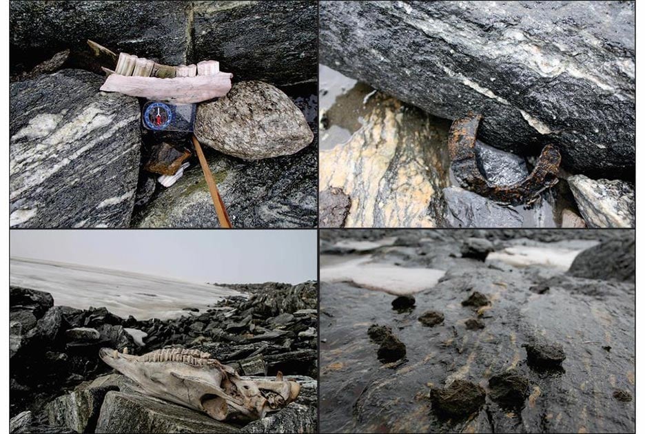
Top Image: These horse-related finds from Lendbreen indicate the route of a Nordic mountain trail: top left) mandible; top right) horseshoe; bottom left) horse skull; bottom right) horse dung. Source: J.H. Barrett & Glacier Archaeology
By Ashley Cowie
