


Nesshenge Revisited: How Does the Reproduction Neolithic Henge Look 15 Years On?
It is not every day that one gets the opportunity to build a replica Neolithic henge earthwork. Moreover, after 15 years of “weathering”, one is amazingly surprised to see that it not only survives but has partly contributed to the enjoyment of the thousands of visitors to Merseyside’s Ness Botanic Gardens. Christened “Nesshenge” by the Antiquity Journal, my replica henge now represents an ongoing archaeological experiment for serious study. And, as an “earthwork” it has been exposed to some of the “best and worst” of the British weather. So, it is time to see what affect this period of time has had on the experimental henge.
- Neolithic Stargazers: Stonehenge's Astronomical Secrets (Video)
- The Winter Solstice at Seven Amazing Megalithic Sites
Background
The story of Nesshenge began some 16 years ago as part of my doctorate research. As luck would have it, I asked the University of Liverpool whether I could utilize one of their many sports fields to map out on the ground the design of Stonehenge. This idea then progressed to expanding the project as part of the university’s contribution towards the City of Liverpool’s 2008 European Capital of Culture.
Referred to as the “ 2008 Stonehenge Rope Experiment using the principle of Occam’s Razor”. The exercise demonstrated how the ground plan of Stonehenge could have originally been designed using my experimental, rudimentary methods of folding ropes, finger counting numeracy and using the Sun’s shadow at midday. For sure, my unique “simple” procedures showed how one length of rope, 180 ft (55m) long, could have been repeatedly folded to mark out a copy of Stonehenge’s extant ground plan. Moreover, a white line marker machine was then used to visibly mark out the design (made by the rope) in order to enhance public viewing (Fig.2).
- Discovery at Stonehenge Challenges Century-Old Theory on Altar Stone Origin
- Builders of Stonehenge Feasted on Parasites Shows Prehistoric Poop Study

Fig.2. Using a length of rope, finger-counting numeracy and the sun’s shadow, it was possible in 2008 to replicate the design of Stonehenge’s ground plan. (Dr John Hill)
Positively, media exposure for the experiment caught the attention of the (then) curator of the university-owned Ness Botanic Gardens, Paul Cook, who subsequently contacted me and asked if I could build a replica henge within a section of his “Wildflower Meadow.” He also offered the Garden’s work force and other materials to help build it.
Selection
The first task was to identify an area within the meadow where the henge could be built. Notably, there were no restrictions on the size of the area, and I think Paul would have been happy with seeing a full-size replica of Stonehenge being constructed. Indeed, it would have made a tremendous visual impact within the central low-lying area of the meadow. However, I wanted to incorporate a number of astronomical alignments within the experimental henge, and this could only be achieved by placing Nesshenge amongst the higher levels of the meadow. But, having selected the appropriate piece of land and surveying it, I had to make some adjustments to its design. In short, the replica would have to be scaled down to almost one third of the size of the real Stonehenge. Having selected the area for Nesshenge, I still had to agree with Paul the various other tasks involved with construction:
- Availability of “spare” stone
- The provision of 56 timbers for the Aubrey holes
- The human effort needed to build it.
Fortunately, Ness Gardens has its own “building yard” with a good supply of medium-sized garden stones that I could use. Also, even back as far as 2008, ecological philosophy determined the choice of the 56 wooden posts I needed to stand in “my” Aubrey Holes. Thus, a number of trees which had already been identified for “trimming” provided excellent timbers for that purpose. Regarding the manual labor required to build the henge, then four gardeners and a mini digger (plus driver) were offered for three full days. Having agreed and scheduled these requirements, the work was ready to start.
Now the dimension for the Outer Ditch at the real Stonehenge covers an area some 360 ft by 360 ft (110m x 110m) but the raised meadow was smaller in size. Compromising, I had to scale down the reconstruction accordingly i.e. using a length of rope 67 ½ ft (20.5m) long to set out the ditch or rather 135 ft x 135 ft (41.1m x 41.1m). And here is a breakdown of all those other measurements at both Stonehenge and Nesshenge as well as their respective calculations for folding the ropes at the latter experimental henge (Table 1).
Table 1. A comparison of measurements between Stonehenge and Nesshenge.
|
Feature |
At Stonehenge |
At Nesshenge |
Calculation for Nesshenge’s features |
|
Diameter of Outer Ditch |
360 ft (110m) |
135 ft (55m) |
Use the 67 ½ ft rope to set out. |
|
Width of Outer Ditch |
13½ ft (4.11m) |
5.062 ft (1.54m) |
Divide the 67 ½ ft rope into 8. Cut off one eight. Fold into 5. Use three lengths to set out Outer Ditch. |
|
Diameter of Inner Bank |
157½ ft. (47.88m) |
59.06 ft (18m) |
Divide the 67 ½ ft rope into 8. Cut off one eight. Use residual rope to set out center line of Inner Bank. |
|
Width of Inner Bank |
18 ft (5.48m) |
6.75 ft (2m) |
Divide the 67 ½ ft rope into 8. Cut off one eight. Fold into 5. Use four lengths to set out Inner Bank. |
|
Diameter of Aubrey Holes Circuit |
141¾ ft (43.2m) |
53.154 ft (16.2m) |
Divide the 67 ½ ft rope into 8. Cut off one eight. Then deduct a further one eight from residual. Use residual length to lay out circuit. |
|
Distance between Aubrey Holes |
15¾ ft (4.8m) |
5.906 ft (1.8m) |
Use the discarded 5.906 ft rope from the Aubrey Circuit above. |
|
Width of South Entrance |
13 ½ ft (4.11m) |
5.062 ft (1.54m) |
Divide the 67 ½ ft rope into 8. Cut off one eight. Fold into 5. Use three lengths to set out width of South Entrance. |
|
Width of North-east Entrance |
36 ft (10.97m) |
13.5 ft (4.11m) |
Divide the 67 ½ ft rope into 5. Cut off one fifth to set out width of North-east Entrance. |
|
Distance of Heel Stone to center of henge |
258.75 ft |
97.1 ft (29.57m) |
Divide the 67 ½ ft rope into 8. Cut off one eight. Roll out 11 ½ times. . |
|
Distance of Slaughter Stone to center of henge |
135 ft (41.1m) |
50.62 ft (15.4m) |
Divide the 67 ½ ft rope into 4. Cut off one quarter and use residual length to set out the Slaughter Stone. |
Getting started
The first “job” with construction was to clear the land upon which Nesshenge would stand. This involved strimming weeds and mowing grass. Fortunately, there were no large trees or excessive shrubs to clear. With the land surface cleared, I then used the 67 ½ ft (20.5m) length of rope to mark out the circumference of the Nesshenge’s Outer Ditch, as well as using wooden poles to set out a ring of posts along that perimeter. Next, standing at the center of this ring, I measured the sun’s shadow to identify a north/south line and the direction of True North (Fig.3A). Then the other cardinal points were obtained by asking a gardener to stand on the north / south line and to hold out both their arms parallel to the ground whilst facing True North: thus, the right arm pointed east and the left arm, west. This action then identified the east and west cardinal points on the circumference of the outer ditch made by the 67 ½ ft rope (Fig.3B). Of course, there are other ways of obtaining the cardinal points, but this was the simplest way to do this here. And this procedure it would also explain how the Neolithic people could accomplish orientation for their monuments without leaving a physical imprint of the archaeological record.

Fig.3A & 3B. My experimental method for achieving orientation. (Dr John Hill)
Finally, once I had identified the cardinal points and determined orientation, it was time to set out all of the internal features at the henge, the dimensions of which are shown in Table 1. Undoubtedly, three days was not enough time to allow men to dig ditches and raise earthen banks solely using prehistoric stone technology - so I had to revert to utilizing modern equipment to finish the job (Fig.4).

Fig.4. Nesshenge in 2008, modern tools were used to dig the ditches and raise the banks. (Dr John Hill)
The Result in 2008
The reconstructed Nesshenge represented an important comparison with Stonehenge’s unique architecture. The real Stonehenge appeared during the Middle Neolithic period, around 3000-2950 BC. It firstly consisted of a ditch and bank earthwork surrounding a central area with two entrances. Then, about 2800 BC a ring of 56 (probable) timber posts were placed in what are now referred to as the Aubrey Holes. Importantly though, and it is noted that after 2008, there has been a new interpretation proposing that these Aubrey Holes might have alternatively contained standing Bluestones instead of timbers. But I believe the evidence for what these holes originally contained is equivocal – it could be timbers, stones or even both and, it is noted, that there are still about 40% of these holes awaiting future excavation and therefore, until they have been examined, we cannot quite be sure what they or actually held.
Then, about 2650 BC, a double arc of standing Bluestones were set out and they remained in situ for almost one hundred years or so before being removed to make space for the raising of the great Sarsen Circle and Trilithons, circa 2550-2450 BC. These Sarsen stones were massive stones, each weighing on average about 35 ton and they were dragged some twenty miles (32.18 km) from the Marlborough Downs to Stonehenge. Finally, after raising the Sarsen stones the Bluestones were repositioned in two formations within the central areas of Stonehenge, sometime between 2200-2000 BC. Finally, around two hundred years later, two crescentic rings of empty pit/holes were dug around the central stone settings (referred to as the X and Y Rings).
Incidentally, I only added a few of the standing stones to the experimental henge to represent the Heel Stone, the Slaughter Stone, the recumbent Altar Stone and the four Station Stones. Also, five (small) uprights were positioned to represent Stonehenge’s Trilithons whilst 30 slabs accounted for the Sarsen Circle lintel stones. Furthermore, I carefully positioned the henge so that it not only incorporated a number of important astronomical alignments that occur at the real Stonehenge, but I aligned Nesshenge towards a “special notch” amongst the south-west horizons, between the Welsh mountains of Moel Famau and Moel Arthur. Indeed, standing at the Heel Stone on the winter solstice (21 st December) one can watch the afternoon winter sun setting between the two mountains (Fig.5).

Fig.5. Nesshenge during the winter solstice sunset (21st December). (Dr John Hill)
By the way, no sooner after building the experimental henge did it come under attack from the elements. Within days heavy rain caused the ditches to flood, and they remained flooded throughout the winter of 2008 (Fig.6). Interestingly, this flooding made me think about the purpose of henge ditches – were they all deliberately meant to flood in this manner? Perhaps they were a source of water for the cattle that were herded by the prehistoric farmers when congregating at henges for trade, feasting and exchange; alternatively, the flooding may have contained some cosmological meaning or even used for ritual bathing by the people. Certainly, the incorporation of water as a natural element within the architectural design of a Neolithic henge is known elsewhere. For example, at the Marden henge (Wiltshire), there, the river Avon was actually forced to flow into segments of its ditch, forcing it to remain in a permanently waterlogged state as, indeed, Nesshenge has done so since 2008.

Fig.6. Nesshenge in 2008. The ditches filled with rainwater. (Dr John Hill)
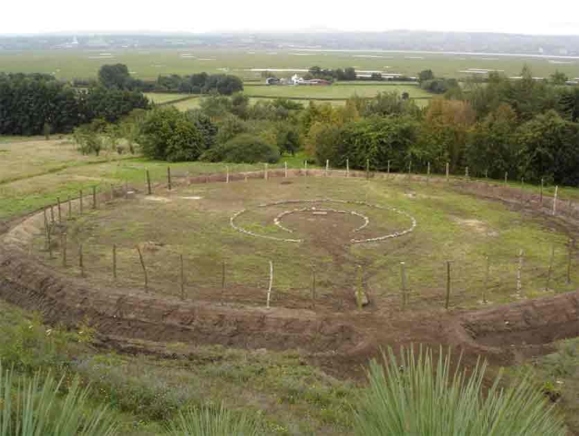
Nesshenge Today (2024 AD)
Nesshenge still survives! And it continues to attract visitors who come to sit and meditate within the “sacred” space it provides. I also understand that some people gather every winter solstice afternoon and enjoy watching the sunset from the henge. Of the 56 timbers that once stood in the Aubrey Holes in 2008, only three remain today. Moreover, they are now rotted and unlikely to stand upright for much longer. The Outer Ditch has silted somewhat, and it still continues to flood along its southern quadrants, however the entire Inner Bank still maintains its form. I did note that “my” Slaughter Stone has been raised upright (although I cannot remember whether I did this some time ago, again for health and safety concerns as it was (is) easy to trip over it when laid flat). Regrettably, the remains of my reconstructed stone-lined Avenue which ran from the north-east entrance towards the Heel Stone, has now disappeared whilst the latter stone is hidden amongst some undergrowth (Fig.7).

Fig.7. Nesshenge today (2024 AD). The South Entrance with adjacent flooded ditches. (Dr John Hill)
I am also pleased to report that reconstructed henge now forms part of the University of Liverpool’s EARTH (Experimental Archaeology Research and Teaching Hub). And hopefully this incorporation will protect the henge for many years to come. Indeed, this teaching hub (including Nesshenge) provides an excellent resource and opportunity for teaching experimental archaeology not only to the Liverpool University students but also to the wider public.
Top image: Fig.1 The experimental henge “Nesshenge” as it looked in 2008. Source: © Dr John Hill
By Dr John Hill
Dr Hill has recently written and published about his methods in a new book called Experimental Archaeology and Neolithic Architecture: Between Design and Construction
In it he states that our understanding of the construction processes involved with British Neolithic architecture needs further investigation. The Neolithic people were preliterate and there is no archaeological evidence of written or pictorial information regarding construction. So how could they build complex monuments like Stonehenge without a plan?
He argues that the Neolithic builders used rudimentary techniques to plan their structures before physically building them (circa 4000 – 2500 BC). Essentially, using ropes to set out the physical design of any structure they intended to build, whilst finger reckoning numeracy dictated how their measured ropes were folded to position the monument’s features. Finally, they used the sun’s shadow at midday to achieve orientation to capture intended astronomical alignments.
Copies of his book can be ordered from Amazon at:
https://www.amazon.co.uk/Experimental-Archaeology-Neolithic-Architecture-Construction/dp/1036400212
You can contact Dr Hill at:
