Library of Congress Obtains Mesoamerican Map from the Dawn of the Americas
The U.S. Library of Congress has recently announced that a unique, indigenous-made map of Mexico from the era of the Nahuatl people's first contact with European explorers is now part of its vast collection.
Library of Congress Obtains a Unique 16 th Century Mesoamerican Manuscript
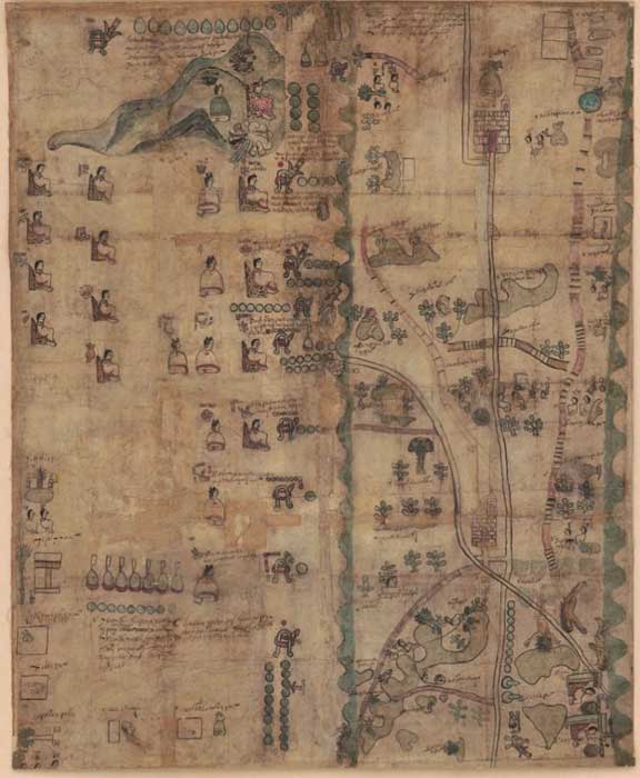
As Live Science reports, the Library of Congress has obtained the so-called Codex Quetzalecatzin, also known as the Mapa de Ecatepec-Huitziltepec, one of the very few remaining Mesoamerican manuscripts from the 16th century. After being in private collections for over a century, the codex has been digitally preserved and is now available online to the general public for the first time. While digitizing the codex at the Library, the Librarian stated: “The acquisition of the map, because of its relevance to the early history of the European contact with the indigenous people of America, makes an important addition to the early American treasures at the Library of Congress, including the Oztoticpac Lands Map and the Huexotzinco Codex. It’s a rare document of world history and American history in general,” in a statement that focuses on the immense cultural value of the specific document, which is one of the few examples of manuscripts of this kind that have endured the severe damages from that period.

Codex Quetzalecatzin Map or The Mapa de Ecatepec-Huitziltepec. Retrieved from the Library of Congress. (Public Domain)
What Codex Quetzalecatzin Shows
So, what do we learn by looking at the Codex Quetzalecatzin? According to the Library of Congress, this 1593 map shows southern Puebla from the church of Todos Santos (now northeast of Mexico City) and Lake Texcoco, to the church of Santa Cruz Huitziltepec, Pue. The map also reveals the genealogy and land ownership for the Nahuatl "de Leon" family from 1480 to 1593. Additionally, experts suggest that the Codex Quetzalecatzin serves as an example of the many cartographic histories that were created by indigenous painters and artists back in the 16 th century, as part of the Spanish royal investigation into the human and community resources in the American colonies.
- Mapping the Menacing Sea Monsters in Medieval and Renaissance Cartography
- Mysterious Map Emerges at the Dawn of the Egyptian Civilization and Depicts Antarctica Without Ice – Who Made it?
- 13th Century Maya Codex, Long Shrouded in Controversy, Proves Genuine

Top half of the Codex Quetzalecatzin Map. Retrieved from the Library of Congress. (Public Domain)
“The codex shows graphically the kinds of cultural interactions taking place at an important moment in American history. In a sense, we see the birth of what would be the start of what we would come to know as the Americas,” John Hessler, curator of the Jay I. Kislak Collection for the archaeology of the early Americas of the Library of Congress, said as the Library of Congress reports. The Library of Congress also reports that in the codex can easily be traced the Spanish influence to the Indigenous people. More specifically, the names of some indigenous people from the higher social classes, such as “don Alonso” and “don Matheo,” consist clear evidence that some indigenous people had adopted the Spanish title “don”, while some of them had even been baptized with Christian names. “The codex relates to the extent of land ownership and properties of the family line known as “de Leon,” most of the members of which are portrayed on the manuscript. With Aztec stylized graphics, the map illustrates the family’s genealogy and its descent from Quetzalecatzin, who in 1480 was the major political leader of the region. It also shows churches, some Spanish place names and images suggesting a community adapting to Spanish law and rule,” Hessler explains.
- The Maya Codices: The Precious Remaining History of an Eradicated Civilization
- Treasures of Mexico: The Mixtec, Aztec & Maya Codices that Survived the Conquistadors
- Evidence of A 2,300-Year-Old Mesoamerican State Society? Immense Palace Complex May Rewrite Mexican History

Bottom half of the Codex Quetzalecatzin Map. Retrieved from the Library of Congress. (Public Domain)
Codex’s Origin
Ultimately, Live Science points out that the codex has a great provenance. The Library obtained the map from the collections of Charles Ratton and Guy Ladriere in France. Also, previous owners include newspaper mogul William Randolph Hearst, who also owned the Jefferson Bible, to the first Viscount Cowdray. The Library of Congress adds that the manuscript belongs to a larger group of interrelated pictographic documents, called “Pinome Group,” from northern Oaxaca and Southern Puebla in Mexico. The codices include the Tecamachalco Canvas, Cuevas Codices and Fragmented Codex, which together show the extent, the people and history of the region.
Top image: Top left section detail of (1593) [The Codex Quetzalecatzin]. [Mexico: Producer not identified] [Map] Retrieved from the Library of Congress. (Public Domain)


![Top left section detail of (1593) [The Codex Quetzalecatzin]. [Mexico: Producer not identified] [Map] Retrieved from the Library of Congress.](https://www.ancient-origins.net/sites/default/files/field/image/Library-of-Congress-Obtains-Mesoamerican-Map.jpg)
