


Was the Devil’s Dyke in England once Part of the Legendary City of Troy?
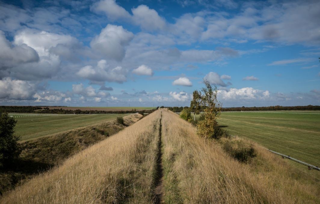
In a small village northeast of Cambridge, near the most northern route of the ancient Icknield Way, a great 'dyke' emerges smoothly from the ground and rises to over two stories high. This incredible earthwork stretches for nearly eight miles, heading southeast to Wood Ditton. This huge bank and ditch are assumed to be of Anglo-Saxon origin and is the most complete of all the dykes in Britain. However, some researchers say that Troy was in fact in this area, and the Devil’s Dyke is proof of that.

Devil's Dyke circa 1853 (public domain)
We visited two parts of the dyke with author David Hatcher Childress and Jennifer Bolm recently, along with local archaeologist Michelle Bullivant. We started our survey at Reach, where the earthwork officially starts, however Michelle quickly corrected what was written on the information board by explaining that it once continued northwest for a few hundred more yards, in to the village to join up with the Fen edge.

Archaeologist Michelle Bullivant and Author Hugh Newman. Credit: Hugh Newman
Devil's Dyke was built in the 'prehistoric' style, looking like the builders were the same team who constructed Avebury henge or the ditches around Maiden Castle in Dorset, only not circular or irregularly shaped, but a dead-straight, mega-earthwork that disappears in to the distance. Whether the dyke was actually constructed around the time of Avebury and Stonehenge, or whether it was a Saxon defense is still undecided by archaeologists.
“There have been several archaeological excavations through the Dyke in the 20th century. In 1973, during the construction of the A14, an archaeological section was excavated and this helped to reveal how the Dyke may have been constructed. It showed that the first stage was a marker bank using topsoil from the immediate area. Material was then quarried from the ditch and was hoisted to the top of the bank in great tips on earth hauling ramps. Gangs of workers were responsible for different sections. However, it is thought that the defenses went out of use after only a few years but it did confirm a construction date in the 5th or 6th century AD.”
However, since then Roman coins have been discovered there, and under Fleam Dyke. Michelle Bullivant also told me that the Romans knew about how the dykes were being used by Boudica’s army in the first century AD. In Fleam Dyke, some early and middle bronze-age pot sherds were discovered, so this could push the date even further back to around the time of Troy (1500 BC) or even to the era of Avebury (3000 BC).

The Devil’s Dyke, Cambridgeshire, UK. (CC BY 2.0)
Who Made the Mysterious Creations, and Why?
When contemplating the immense size of the dyke, I often wonder what must have gone through the minds of the builders when the foreman said, "Ok, this dyke is going to be at least 30 feet high, with a rampart of 20 feet below ground level and, let’s say, make it eight miles long?" The sighs must have echoed through eternity.
The official line that the “Saxons did it” suggests there must have been rather a lot of them, but why? That is the big mystery of this incredible engineering marvel. It appears to have been put there to stop something coming through from the southwest, as the ditch is on along the inland edge. Whether it was the invading tribes from the southwest and Queen Boudica was trying to protect her territory in the first century AD, or whether it may have been constructed much earlier, will be discussed shortly, but like with many earthen henges (such as Wandlebury,) defense may not have been its primary purpose.
Suggestions from various researchers propose it was used as a 'toll' for travelers upon the Icknield Way, as this ancient track had multiple pathways along its length, not just a single track. It’s interesting to see on old maps that the different tracks on the Icknield Way do tend to stretch about as wide as the total width of the dykes, strengthening the 'toll' theory for the purpose of its construction, to be able to control trade and movement in the area.

Icknield Way, Lewknor, Oxfordshire, Great Britain. (David Hawgood / CC BY-SA 2.0)
History of the Dykes
During the Middle Ages it was known as 'St Edmund's Dyke', because it marked the limit of the jurisdiction of the abbots of Bury St. Edmunds. From the Middle Ages there are references to the 'Great Ditch'. During the 11th century siege of Ely by William the Conqueror, it was referred to as 'Reach Dyke'. Devil's Dyke or Ditch is a post-medieval name, probably deriving from a belief that such landforms must be of supernatural origin.
In 'Legends of the Fenland People', Christopher Marlowe describes an old story associated with the dyke saying it was constructed by "… a race of giants, renowned alike for cunning, strength and ferocity". Here is the summary of the legend:
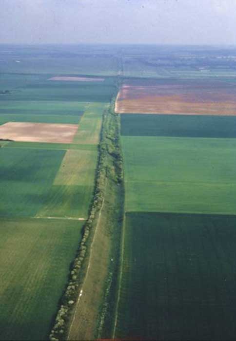
Devil’s Dyke Aerial Shot (Courtesy CCC)
"Long, long, ago, when the area around Reach was a forest, there lived a chief called Hrothgar. He lived at a time when gods and demons were thought to control the earth and one demon in particular was terrifying - the fire demon! To the horror of the chief, it appeared that the fire demon desired his beautiful daughter, Hayenna. Hrothgar told his daughter not to worry, as his very good friend, the water god, was the sworn enemy of the fire god. He knew that the water god could communicate between the under and over world and would keep her safe.
One night Hrothgar had a dream. In his dream, an old man appeared and told him that the fire demon had a new ally in the tempest god. ‘You must prepare for a great battle’, the old man told him. The next day, Hrothgar told all the giants of the forest his plans. First, they cut down all the trees to make a wide clearing. During the next three days, they built a great ditch from the river to Mount Dithon (Wood Ditton), many feet deep and seven miles long.
The tempest god had watched their work with interest and scorn. Just as they were starting to tire from the hard work, he sent a great storm to blow down the trees on top of them. The storm also brought rain, hail and snow in great quantities. The giants of the forest rounded on Hrothgar, saying he should not have angered the gods and should not have crossed the powerful fire demon. ‘Do not be afraid,’ Hrothgar told them. ‘My good friend, the water god will protect us.’
At that very moment, the rain ceased. Suddenly, under a great cloud of smoke, a terrifying wall of fire rushed towards the ditch. All but Hrothgar fled. Despite his fear, he came out from shelter and, with his bare hands, dug away the remaining strip of earth, separating the River Cam from the ditch. The water poured into the ditch with a mighty, deafening roar! The fire demon was powerless against this mighty wall of water and the fire died down, the tempest stopped and his daughter was safe. Rejoicing, the local people placed treasured items in the new stream, to thank the water god for his help. The ditch, the Devil's Dyke is still there. The fire demon never troubled the population of Reach again.”
However, the devil may still be around, for there have been many sightings of a large black ghostly dog with fire in his eyes. He is said to bound along Devil's Dyke, his blood-red eyes as big as saucers, guarding the dyke and, some also say, protecting treasure buried deep beneath it. The legends of ‘Black Shuck’ have also been recorded near Arbury in Cambridge and throughout East Anglia. Another legend tells that the Devil arrived at a wedding at Reach church, but uninvited as he was, the guests turned him away. As he fled in anger, his huge flaming tail scored a groove in the earth, forming the dyke.
Legends of giants abound in the Cambridgeshire area. At Cherry Hinton, the sacred spring called the "giants grave" still produces clean drinking water and nine skeletons of ‘unusually large height’ were discovered in the 1800's in the War Ditches, an ancient earthwork upon the Gog Magog Hills. There are also the chalk hill figures, rediscovered by Tom Lethbridge in the 1950's at Wandlebury, who had heard about giants being buried on the hills. Children in the early 1900's were told to not go up the hill, in case they met the giants.

Fleam Dyke (public domain)
There are several other similar dykes around Cambridgeshire, that lie roughly parallel and all seem to be centered on the Gog Magog Hills, where Wandlebury Henge sits upon. Northeast of Wandlebury is Fleam Dyke that runs for three miles (4.8 kilometers) from Balsham to Fulbourn and has a 20 to 25 feet (6 to 7.6 meters) high bank with a ditch.
“The main part of Fleam survives today as a footpath and parish boundary, but historically the northern part was also the boundary between Flendish and Staine Hundreds. The Moot for these Hundreds was at Mutlow Hill, a Bronze Age barrow which had clearly been an important landmark for many centuries before its use as an Anglo-Saxon meeting place. Apart from the 4,000-year-old cremated burials for which it was originally built, rare third century BC Greek coins have been found close to the burial mound. It was reused in Roman times for a temple, and it is no accident that Fleam Dyke passes right beside it. Mutlow rests on the top of a hill, and overlooks the junction of several routeways (including the Icknield Way) where they meet and cross Fleam Dyke.”

Four Dykes of Cambridgeshire
Two smaller dykes exist southwest of Wandlebury, the Brent Ditch and Bran Ditch that once again, lie parallel to the Fleam and Devil's dyke, and stretch along the width of the Icknield Way. In 1841 Charles Henry Hartshorne wrote about the four dykes along the Icknield Way: " For they are one and the same work, though bearing different titles at each extremity.”

The profiles of the Cambridgeshire dykes, (based on Hartshorne's Salopia Antinqua, 1841.) (CC BY-SA 3.0)
City of Troy in England?
A startling theory regarding why the dykes were built is presented by Iman Wilkens in 'Where Troy Once Stood'. He suggests that they were built by the Achaean invaders coming in from northeast coast preparing to invade Troy. (It should be noted at this point that he believed Troy was not ever in Turkey, but actually on the Gog Magog Hills around Cambridge). This deduction was made because the ditch was on the southern side of the dykes, which was the best place to have it to stop horse-riding warriors or chariots breaking through the defense, if they were coming from the southeast. As the Achaeans gradually progressed southeast, they would build more dykes, until the final battle of Troy supposedly took place at Wandlebury. However, it could be that Queen Boudica had the same idea, and was taking control of more land, one dyke at a time, heading further south along the Icknield Way.
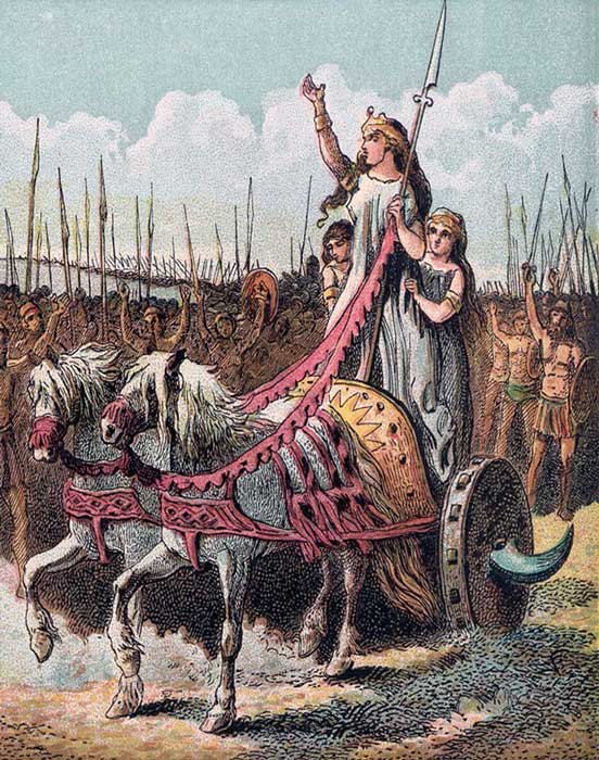
Boudica, leader of the rebellion against the Romans. (Public Domain)

According to Wilkens, the terrain, flora, fauna, climate and place names of Troy do not match those of the site in Turkey, but somewhere that has a green rolling landscape, bad weather, and was surrounded by circular earthworks and great dykes. Through thirty years of investigation, he re-plotted the site of Troy onto the Gog Magog Hills near Cambridge, with Wandlebury as its omphalus, or center point.
Three hundred pages of inspired and diligent research put this theory into the realms of possibility, but does the archaeological record and mythology of the area really support the idea that back around 1200 BC, a great war involving hundreds of thousands of warriors took place in this part of East Anglia? Most academics and historians sneer at such an idea, but a growing number of them are starting to take his theory seriously for a number of reasons.
One of those reasons is the fact that a huge number of Bronze Age artifacts, including armor and weaponry, have been found in the vicinity. Plus, hundreds of war-wounded skeletons have also been found on what now looks like an ancient battlefield. However, skeletons and some artifacts are not enough to confirm his theory, but, tantalizingly, the dykes regularly get mentioned throughout Homer’s ancient Greek epic, The Iliad.
Wilkens argues, “ As these dykes obviously have no hydraulic function they may have had a military purpose by forming a barrier linking the river Cam to the west to dense forests on the hills to the east. The plain itself had already been cleared around 2000 BC according to archaeological research. Although the dykes and ditches seem to be meant as barriers to horse-drawn war chariots, it was never clear for which war. The dykes were not mentioned by Roman historians as they were probably of no use to the Roman army. But after the discovery of a Roman coin and potsherds under one part of the Fleam Dyke, the earthworks were believed to date from the time of the tribal warfare between the Mercians and the East Angles in the sixth and seventh century AD. Although this has been confirmed by radio-carbon dating of parts of the Fleam Dyke, elements of much older earthworks seem to have been used in the most eastern part of the dyke where a few potsherds of the early and middle Bronze Age were found.”

The Gog Magog hills, Cambridge, England. (Public Domain)
One example that Wilkins points out is when the Trojans attacked the camp near the sea with their horse-drawn chariots, they were slaughtered by the Achaeans, and the frightened horses ran with their empty chariots over the wardykes, back to Troy. Literally translated, the relevant passage reads as follows:
“Even beneath Agamemnon, son of Atreus, fell the heads of the Trojans as they fled, and many horses with high-arched necks rattled empty cars over the dykes of battle lacking their peerless charioteers, who were lying upon the ground dearer far to the vultures than to their wives”. (XI,158-162)
The full theory Wilkens provides sounds far-fetched on initial inspection, but his simple comparison of the East Anglian landscape to what is written in The Illiad is striking and convincing, yet the archaeological world will not want to change the location of Troy "officially" as it would require hundreds of history books to be rewritten.

Triumphant Achilles dragging Hector's body around Troy. (Public Domain)
I am fascinated by the similarities and 'coincidences' between the Avebury landscape and the one around Wandlebury. They both have spectacular crop circles in the surrounding fields, and are connected by the Mary energy line. Both are large circular earthworks, both have the Icknield Way nearby (called the Ridgeway in Wiltshire,) and both have a huge dyke within a few miles. In Wiltshire the 25-mile-long (40 kilometer) Wansdyke dominates the landscape south of Avebury. On the border of Wales and England is Offa's Dyke, which stretches for an incredible 176 miles (283 kilometers) coast to coast and is said to “be of the same hand as the Devil's Dyke”.
Ancient Mystery
Whoever built the Cambridgeshire dykes, whether Saxons, Boudica, the Achaeans, or the ancient megalith builders, their mystery is as profound as the megalithic sites that dominate the greater British landscape. The man-hours and sheer size of these earthworks puts the likes of Stonehenge in the dark. However, their design and style shows remarkable correspondences with Avebury and other great earthwork monuments, and one day we may discover the true purpose of these incredible earthen scars across the mysterious and magical landscape of East Anglia.
Top image: The Devil’s Dyke (RCGroups)
By Hugh Newman
Hugh Newman was brought up in Cambridge, and is an explorer, antiquarian, and author of Earth Grids: The Secret Patterns of Gaia’s Sacred Sites (2008), and co-author with Jim Vieira of Giants On Record: America’s Hidden History, Secrets in the Mounds and the Smithsonian Files (2015). He organizes the Megalithomania Conference every May in Glastonbury, and hosts regular tours to Peru, Mexico, Egypt, Turkey, Java and other locations.
References
Nigel, Helen Strudwick, 2016. “What is the Devil’s Dyke?” DevilsDykeMM.org.uk [Online] Available at: http://www.devilsdykemm.org.uk/devilsdyke
Tim Malim, former Manager of the Cambridgeshire County Council Archaeological Field Unit. 2016. “Roman Road and Fleam Dyke.” FRRFD.org.uk [Online] Available at: http://frrfd.org.uk/
Charles Henry Hartshorne , “Salopia Antiqua”. 1841-pub. J. W. Parker
Where Troy Once Stood' by I.Wilkens, revised edition; Part II, Chapter 1; page 4 of 22 [Online] Available at: http://www.troy-in-england.co.uk/trojan-war-1.htm

Comments
I agree with Anthony’s comment above that Iman Wilken’s ideas are so lacking in evidence and incorrect as to be not worth serious consideration. For a start, the place names and descriptions of cities in the Illiad can be traced back to exact matches in Bronze Age Greece, there is no match for a Troy with great walls at Gog Magog, the names in the Illiad are reflected in the Pylos Bronze Age tablests but nowhere in western Europe, why is the legend only present in Greek literature not anywhere else ? Why do so many objects mentioned in the Illiad match Bronze Age or Iron Age Greek articfacts and not western european ones ? It just goes on and on.
This article poses the question ‘Was the Devil’s Dyke in England once Part of the Legendary City of Troy?’. The answer is, no, it was not. The core of the arguement lies with Wilkens’s far-fetched claim that the Trojan War took place in East Anglia, with the myth of the arrival of Brutus of Troy in Britain three generations later as a – perfectly illogical – piece of corroborating evidence. I addressed this latter aspect of Wilkens’s (ludicrous) argument on p. 197 of my book “Brutus of Troy, and the quest for the ancestry of the British”. There is no proper evidence for Wilkens’ theory at all, whereas the weight of scholarly and archaeological evidence that the site of Hisarlik in north-western Turkey is the real Troy is considerable, and on-going investigations there are providing more, not less evidence for this. Hugh Newman states “According to Wilkens, the terrain, flora, fauna, climate and place names of Troy do not match those of the site in Turkey”. He has clearly never been there; he should, for he would find that the opposite is true. He should also read Professor J.V. Luce’s excellent book “Celebrating Homer’s Landscapes”, which is based on close analysis of Homer’s text and a careful comparison of all the salient details with the topography of the Troad and the archaeological digs at Hisarlik itself.