


What Do Astronauts, Atlantis, and Africa Share? The Richat Structure!
Tucked away in Mauritania, surrounded by the imposing, shifting dunes of the Sahara Desert, lies the Richat Structure. A spectacular rock formation of many names, the “Eye of the Sahara” has guided astronauts, inspired those seeking the lost city of Atlantis, and puzzled geologists. Yet, you could stroll through this magnificent geological feature without ever appreciating the concentric stone circles all around you. How has the Richat Structure, something visible only from space, generated so much discussion, curiosity, and awe?
1960s Gemini Astronauts First Saw the Richat Structure!
The Richat Structure, or Guelb er Richat, lies a short distance from the town of Ouadane, which was once a hub of human learning in west-central Mauritania, on the west coast of the bulge of Africa.
- Lost City of the Kalahari: Experts Search for Traces of Ancient Desert Civilization
- Ancient Knowledge from Irish Manuscripts Used to Track Volcanic Activity and Climate Change
As a testament to how difficult it is to observe the true scale of the formation from the ground, little was known regarding the Richat Structure until man ventured into space. From Earth’s orbit, Gemini-mission astronauts were the first to photograph what they dubbed the “Eye of Africa” in the 1960s, and it has since become a landmark for human beings orbiting the Earth.
The Richat Structure: A Dome and Scattered Rings of Stone
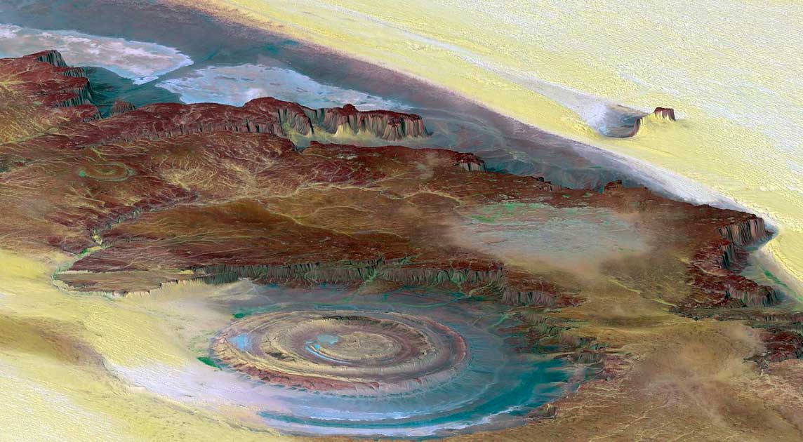
The Richat Structure features a 198 meter (650 foot) tall dome composed primarily of breccia; a type of rock composed of numerous smaller rocks fused together. Geologists classify this central plateau as a domed anticline (folding rock in an arced shape, with the oldest rock at the center). Surrounding the plateau are concentric rings of stone with low valleys between each, forming a distinctly eye-like shape when viewed from above.
The structure is massive, measuring approximately 40 kilometers (25 miles) wide, and is composed of a variety of igneous and sedimentary rock. While the composition and structure of the Richat are well documented, its origins are a source of continued debate.
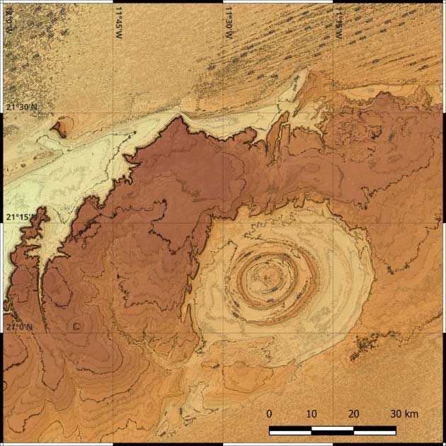 Topographic map of the Richat Structure. (Vallee / CC BY-SA 4.0)
Is the Richat Structure the Lost City of Atlantis?
Around 360 BC, Grecian philosopher Plato wrote “Plato’s Dialogues,” in which he detailed a grand city called Atlantis. Modern scholarship regards Atlantis as a myth, a rhetorical device, but this has not stifled enthusiastic speculation that the city was real, nor a shortage of people looking for its location.
A YouTube video posted on the Bright Insight channel claims the Richat Structure as the site of the lost city. Bright Insight host Jimmy presents a series of arguments in favor of this alongside a handful of screenshots from a 2011 documentary entitled “Visiting Atlantis,” which posits the same theory. Jimmy’s arguments include:
- Atlantis was destroyed 11,600 years ago, a time frame which corresponds to the Younger Dryas period, a time of glacial conditions that caused sea level fluctuation and devastating fires.
- Plato describes Atlantis as having a central island surrounded by concentric rings of alternating water and structures; this description matches the Richat Structure.
- Atlantis was supposedly 127 stadia, or 23 kilometers (14 miles) across, which matches a portion of the Richat. Jimmy does note that he used Google Earth to measure the distance, which may not be completely accurate.
- Atlantis lay in the shadow of mountains to the north, through which rivers flowed down into a wide valley, aligning with the Richat Structure.
- There appears to be evidence of water draining out of the Richat Structure into the ocean, suggesting it was once surrounded by water, as was Atlantis.
- The Great Berber Kingdom of Numidia in the Shadow of Rome
- The Sahara As We Know It Today Versus The Green Sahara It Once Was!
While the video makes for an interesting 20-minute watch, there are many who vehemently disagree with its theory and arguments. Their arguments are, respectively:
- The Younger Dryas occurred between 12,900 and 11,700 years ago, one hundred years outside the timeline of Atlantis’ destruction. Additionally, the period of glacial conditions lasted for 1,200 years along Earth’s equatorial regions (affecting North America more than anywhere else); Atlantis is said to have been destroyed in a single, cataclysmic event over the course of one day.
- The rings of the Richat Structure are broken and incomplete, thus it is unclear how many would have been filled with water, if any. Additionally, there is no evidence of the canal running through the rings cited by Plato.
- Scientific measurement of the Richat Structure puts it at approximately 40 kilometers (25 miles) wide, meaning one must ignore 17 kilometers (10.5 miles) for Atlantis to fit.
- There are mountains to the north, but this is hardly a unique feature. Skeptics also question how well the description of Atlantis being surrounded by “flat plains” fits the Sahara Desert.
- The Sahara is 4.6 million years old and there is no evidence it was covered with water just 12,000 years ago.
- Additionally, skeptics wonder why there have been no archaeological discoveries made on the Richat Structure if Atlantis used to lie on top of it.
While the argument rages on as to whether the Richat Structure used to be the site of an ancient civilization, scientists have been occupied with an entirely different question: how did it form?
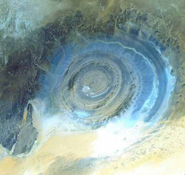
Satellite image of the Richat Structure (false color). (NASA/GSFC/MITI/ERSDAC/JAROS, and U.S./Japan ASTER Science Team / Public domain)
The Science of the Eye of the Sahara
When first studied, scientists posited that the “Eye of the Sahara” was an astrobleme, the result of a meteoric impact. Upon closer inspection, however, it was discovered that none of the rock showed any signs of shock processes.
Recent scholarship has discovered that the Richat is 100 million years old and was formed by volcanic activity. Deep underground, a massive cavern of magma formed and caused the Earth’s surface above it to bulge upward. Boiling fluid then dissolved the limestone around it, causing the structure to weaken and collapse. On the surface, thousands of years of erosion formed the rings and valleys where canals of magma had formed or collapsed. Magma contained within the central dome hardened to form the breccia massif.
One question, however, continues to elude explanation: the Richat Structure stands alone, whereas most volcanoes form in groups.
- Atlantis as Ireland - The Emerald Enigma
- Avalon: A Real Island Obscured by Legend, or Just a Legendary Island?
Regardless of whether you believe the Guelb er Richat was once the center of an ancient, Atlantean civilization or not, the fact remains that it is an extraordinarily beautiful structure. Astronauts have long been awed by its majesty and use it to guide them as they float across the cosmos. Geologists have studied the enigma of the structure and scratched their heads for decades over how it got there.
The Richat Structure, the “Eye of the Sahara,” the “Eye of Africa,” the Guelb er Richat, whatever you want to call it, is a massive stone formation in the shape of an eye that went unnoticed for millennia and continues to evade comprehension today. There’s a strange majesty in knowing nature still holds mysteries for mankind to ponder.
Top image: A topographic reconstruction from satellite photos of the Richat Structure with false coloring. False coloring as follows: Brown: bedrock; Yellow/white: sand; Green: vegetation; Blue: salty sediments. Source: NASA/JPL/NIMA / Public domain
By Mark Johnson
References
Dietz, R., Fudali, R., and Cassidy, W. 1969. Richat and Semisyat Domes (Mauritania): Not Astroblemes. GSA Bulletin vol. 80, no. 7.
Matton, G. and Jebrak, M. 2014. The “Eye of Africa” (Richat Dome, Mauritania): An Isolated Cretaceous Alkaline-Hydrothermal Complex. Journal of African Earth Sciences vol. 97.
Novella, S. 2018. No – Atlantis Has Not Been Discovered in North Africa. Available at: https://theness.com/neurologicablog/index.php/no-atlantis-has-not-been-discovered-in-north-africa/.
Richat Structure. Earth Observatory. Available at: https://earthobservatory.nasa.gov/images/92071/richat-structure.
R.K. Eye on the Eye. Natural History vol. 114, no. 9 (2005).
Tapon, F. Going into the Eye of the Sahara – The Richat Structure. Forbes. Available at: https://www.forbes.com/sites/francistapon/2018/07/30/going-into-the-eye-of-the-sahara-the-richat-structure/?sh=3994a223cf5b.
The Lost City of Atlantis – Hidden in Plain Sight? Lost Ancient Human Civilizations. Bright Insight – YouTube. Available at: https://www.youtube.com/watch?v=oDoM4BmoDQM.

Comments
A zero was almost certainly removed from Plato’s timeline, which has the destruction of Atlantis at 11.5k BC vice 115k BC, which is when the Ice Age suddenly began. Let’s not forget that there are also pieces dubiously missing from those manuscripts. But his information may have come from oral history, or otherwise ancient texts that are no longer ‘available’, passed down by survivors of that cataclysm, and the long, dark nuclear winter that followed. Prior to the Ice Age, there were NO ICE CAPS, and seas would have easily been high enough for the now-dry valley to have been an inland sea estuary, perfectly fitting Plato’s description. Other than the timeline, it all fits, to include (from what I just learned in this article) the red, white and black stone the Atlanteans used, as Plato described. Look at this: https://www.alexstrekeisen.it/english/sedi/breccia.php
Nobody gets paid to tell the truth.