


A Bronze Age Rock Has Become a 'Treasure Map' for Researchers
A piece of rock, adorned with mysterious markings that have remained largely unstudied for 4,000 years, has emerged as a remarkable "treasure map" for archaeologists. This ancient artifact, known as the Saint-Belec slab, is now guiding researchers on a quest to uncover hidden archaeological sites throughout north-western France.
Reading Europe’s Oldest Map
In 2021, researchers declared the Saint-Belec slab as Europe's oldest map, sparking a fervor of curiosity. Since then, archaeologists have diligently worked to decipher its enigmatic etchings, aiming to not only date the slab but also rediscover long-lost monuments.
Yvan Pailler, a professor at the University of Western Brittany (UBO), commented on this unique approach, saying, "Using the map to try to find archaeological sites is a great approach. We never work like that.", reported AFP.
Traditionally, archaeologists rely on sophisticated radar equipment, aerial photography, or serendipitous discoveries during urban construction projects to unearth ancient sites. However, the Saint-Belec slab has opened a new path.
"It's a treasure map," exclaimed Pailler. But this treasure hunt has only just begun.
The ancient map delineates an area spanning approximately 18.5 by 13 miles (30 by 21 kilometers). Clement Nicolas, Pailler's colleague from the CNRS research institute, explained that in order to read the map, they must survey the entire territory and cross-reference the markings on the slab. This monumental task could span over 15 years!
Nicolas and Pailler were part of the team that rediscovered the slab in 2014, although it was initially uncovered in 1900 by a local historian who failed to grasp its significance. In recent weeks, French experts, along with colleagues from various institutions in France and abroad, have been working tirelessly to decode its mysteries.
"Some engraved symbols made sense right away," shared Pailler. In the slab's rugged patterns, they discerned the rivers and mountains of Roudouallec, a region in Brittany located approximately 310 miles (500 kilometers) west of Paris.
- Mysterious Brittany Rock Inscription Finally Solved, Revealing Tragic Death
- Phantom islands on ancient maps dismissed as mirages, myths, or mistakes

The first photograph of the Saint-Bélec slab, when it was found by Paul du Chatellier in Leuhan, Finistere, Brittany, France in 1900. (Inrap)
Researchers scanned the slab and compared it with modern maps, revealing an approximate 80 percent match. However, they are still in the process of identifying all the geometric symbols and their associated legends.
The slab features numerous tiny hollows that researchers believe could point to burial mounds, ancient dwellings, or geological deposits. Deciphering the meaning of these hollows may unlock a trove of new discoveries.

Overhead view of the Saint-Bélec slab. This ornate slab forms a homogeneous composition with covering engravings, identical in technique and style, forming an inseparable whole. Also note the repetition of patterns (cups, geometric shapes), linked together by a network of lines. These elements allow, according to C. Delano Smith, to recognize a cartographic document. ( Denis Glicksman / Inrap)
The Saint-Belec Slab: Found, Acquired, Lost and Rediscovered
The Saint-Bélec slab was first discovered in an excavation by Paul du Chatellier in Leuhan, Brittany, France in 1900, inside an early Bronze Age barrow or grave mound.
It was moved to a private collection in the same year it was found. And then, in 1924, it was acquired by the French Musée des Antiquités Nationales, which is today known as the Museum of National Archaeology.
Till the 1990s, the Saint-Bélec slab lay forgotten in a niche in the castle moat at Mr. du Chatellier’s home, the Chateau de Kernuz, which is about 25 miles (40 km) southwest of Leuhan (where the slab was unearthed).
In 2014, the slab was rediscovered in the chateau. And in 2017, the cooperative research team began their examination of the slab and published their findings in 2021.
The findings proved to be incredibly important. The Saint-Belec slab was conclusively interpreted as the oldest discovered cartographical representation of a known territory in Europe. Specifically, this was the territory and valley around the River Odet, in Western France. BU post-doctoral researcher Dr. Clement Nicolas, told the BBC that this was “probably the oldest map of a territory that has been identified.”
Photogrammetric coverage, geo-locating and high-resolution 3D surveys confirmed to 80% accuracy for an 18-mile (29km) stretch along the Odet and its nearby valley, which is the area covered by the ancient stone map.
At the time, Dr. Nicolas stated:
“There are several such maps carved in stone all over the world. Generally, they are just interpretations. But… this is the first time a map has depicted an area on a specific scale… probably a way to affirm the ownership of the territory by a small prince or king at the time.”
- Ancient Settlement Network Found Mapped in Stone in Mexico
- A Guide to the Stone Circles of Britain, Ireland and Brittany

Lifting and positioning of the Bronze Age stone map that was luckily rediscovered in 2014 in the chateaux cellar. (Clément Nicolas, Yvan Pailler / Inrap)
Understanding an Ancient Stone Map With the Latest Science
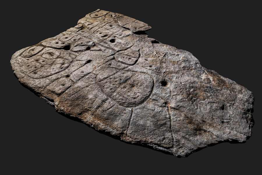
The team recorded the surface topography of the Bronze Age slab and carried out an analysis of the morphology, technology, and chronology of the engravings. What they found was a trapezoidal motif at the center of the slab, which had convex edges. This trapezoidal shape was deeply engraved and bore two axes: a horizontal axis from edge to edge, and a vertical axis that was slightly broken and more difficult to decipher initially. Furthermore, a series of complex patterns, linked by a network of pecked lines, are dotted all over the stone slab.
Three factors related to prehistoric cartography revealed that this was indeed an ancient map:
- The homogenous composition with engravings identical in technique and style
- The repetition of motifs
- The spatial relationships between the lines
To confirm their hypotheses, the Saint-Belec slab was compared with similar representations from European prehistory.
The map’s central motif or line has been interpreted as an enclosure, probably from where the territory emanated or where it was centered.

Detail view of a deeply pitted oval motif with a cup in its center. The picketing technique produces splintering of the shale, forming halos around the patterns. (Denis Glicksman / Inrap)
Firstly, it goes without saying that the ability of prehistoric societies to engage in formalized cartography and mind-mapping, was much more advanced than previously thought.
Secondly, the Saint-Belec slab is contemporaneous with the famous Nebra sky disk from Germany which is date to about 1600 BC. The Nebra sky disk Nebra is considered to be the oldest concrete depiction of the cosmos in Europe.
Finally, there probably existed a political entity led by a prince or a king, who wanted their territory to be literally cast in stone.
Top image: Overhead view of the Saint-Bélec slab. Source: Denis Glicksman / Inrap
By Sahir Pandey
