

Fact Check verdict: Fringe. Pottery, carbon dating and simple stake-and-cord methods all tie the lines to the Nasca people, with no sign of outside help.
Few ancient sites have drawn as many alien claims as the Nazca Lines, the giant figures and long straight lines scraped into the desert of southern Peru. For more than 50 years, books and television shows have suggested aliens made the lines, or that local people made them to guide or signal aliens. Were they?
According to the archaeological evidence, the figures belong to the Nasca culture that lived beside the pampa, and an experiment shows they could be laid out with stakes and cord. Why they were made is still debated, but no evidence points to builders or intended viewers from beyond Earth.
What the evidence says
UNESCO, which lists the site as World Heritage, says the geoglyphs of Nasca and the pampas of Jumana lie "some 400 km south of Lima" and cover about 450 square kilometers. Its listing says the lines "were scratched on the surface of the ground between 500 B.C. and A.D. 500," and depict "living creatures, stylized plants and imaginary beings, as well as geometric figures several kilometres long."
The method was simple, and the 2024 PNAS study by Masato Sakai of Yamagata University and colleagues at IBM describes geoglyphs as "motifs created on the ground by manipulating surface stones or gravel." One of its drawings shows the result as three colors on the desert floor, white where "stones removed," dark brown for "piled stones" and light brown for the "original surface."
The Sakai team writes that, based on the likeness between the figures and painted pottery, "line-type figurative geoglyphs were probably made during the Nasca period (100 BCE to 650 CE)." It adds that pottery from the Early Nasca period, 50 to 300 CE, was found at the "whale" and "monkey" figures. UNESCO's range, 500 BC to AD 500, differs slightly from the survey team's.
Joe Nickell, writing in the Skeptical Inquirer in 1983, pointed to a carbon-14 date. "Wooden stakes mark the termination of some of the long lines and one of these was dated to A.D. 525 (+/- 80)," he wrote. He added that the Nazca people's "graves and the ruins of their settlement lie near the drawings."
Using AI across the whole region, the 2024 survey reports "the discovery of 303 new figurative geoglyphs within only 6 mo of field survey, nearly doubling the number of known figurative geoglyphs." Most are small relief figures that "depict mainly human motifs or motifs of things modified by humans, such as domesticated animals and decapitated heads (81.6%)." They lie on average 43 meters from ancient trails. The team concluded they were "most likely built and viewed at the individual or small-group level."
How the alien idea took hold
The alien reading is best known from Erich von Däniken's Chariots of the Gods? In the 1970 edition Nickell quotes, von Däniken argues the figures could have been "built according to instructions from an aircraft." According to Nickell, he also called the large drawings "signals" and the wider lines "landing strips," and he wrote that "it is surely oversimplifying things to attribute the geometrically arranged lines to the Nazca culture for that reason alone."
The landing strip idea drew a dry reply from Maria Reiche, the German-born mathematician who for years mapped and tried to preserve the lines. Noting the soft ground, she said, as Nickell quotes her from a 1975 account, "I'm afraid the spacemen would have gotten stuck."
Nickell traced the runway comparison to Paul Kosok, the first to study the markings. Kosok wrote in 1947, in a passage Nickell quotes, that "When first viewed from the air, [the lines] were nicknamed prehistoric landing fields and jokingly compared with the so-called canals on Mars." By that account the comparison began as a joke.
The alternative view
The strongest argument for an outside hand is scale. The largest figures are hard to make out from the ground, and some writers doubted that people without aircraft could draw them so accurately. Von Däniken, in Nickell's quotation, wrote that "Classical archaeology does not admit that the pre-Inca peoples could have had a perfect surveying technique."
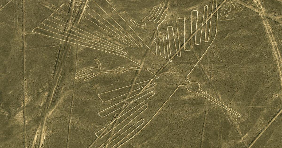
Nickell tested that claim on a Kentucky landfill, where on August 7, 1982, he and five relatives set out to copy the "440-foot-long condor" using a center line, ropes marked in a unit "gleaned by Maria Reiche" from the drawings, and a wooden T for right angles. "Some nine hours, one meal, and much ice-water later, we had plotted and staked the last of 165 points and had connected them with twine," he wrote.
The copy was photographed from "just under 1,000 feet." Nickell reported that the results "were so accurate that we are convinced we could have easily produced a more symmetrical figure by this method." Smaller figures, he noted, such as a fish "only 80 feet long," can be seen from the ground.
Reiche had reached a similar view of the method. Nickell reports that she found stones or holes at the centers of arcs and concluded that straight lines could be made by stretching a rope between two stakes. Her explanation for the lines leaned toward the sky.
That idea remains debated, and Nickell quotes William Isbell's 1978 summary, which says Reiche had long pointed out lines marking the sun at the solstices, and that a computer study by Gerald Hawkins "failed to demonstrate that a majority of the lines had astronomical significance" but found more solar and lunar alignments than chance would predict. The Sakai team lists five main hypotheses for the lines and reports the "predominant opinion" that linear geoglyphs "were an integral part of the Nasca sacred space."
Where this leaves it
According to the sources consulted, the Nazca Lines were scraped into the desert by people who lived beside it, using methods a small team has copied with stakes, rope and twine. Their purpose is still argued over. The Sakai team links the network to pilgrimage to the temple center of Cahuachi.
The 2024 survey's split between small trail-side figures and giant ritual figures is indicative rather than conclusive. It fits a human story of people walking, gathering and marking the ground. The idea that aliens made the lines, or that they were drawn for alien eyes, remains less likely than the long work of the Nasca people that the site's history records.
How we checked this
Read for this check: the UNESCO World Heritage listing for the Lines and Geoglyphs of Nasca and Pampas de Jumana, the 2024 PNAS article by Sakai and colleagues in its open copy, and Joe Nickell's 1983 Skeptical Inquirer article in an archived copy. Von Däniken, Kosok, Reiche, Isbell and Hawkins appear here only as Nickell quotes or summarizes them, because their original works were not read. No current viral X post making the alien claim was found, so this check treats it as a widely told story.
No interviews were conducted, earlier Ancient Origins coverage was not a source, and every quote was checked against a saved copy on October 27, 2026.
How we label claims: see How we check evidence.
More in this series: Göbekli Tepe, the Sphinx and Atlantis: what the evidence says.
By Aris Manus
Claim by claim
- Fringe: The Nazca Lines were made by or for aliens. Reason: no physical evidence supports it, and the pottery, dating and layout of the lines point to local builders.
- Established: The figures were made by ancient people of the region. Reason: Nasca pottery has been found at the figures, and a wooden stake at one line was carbon dated to about AD 525, Joe Nickell reports.
- Established: The lines were made by moving surface stones. Reason: UNESCO and the 2024 PNAS survey team both describe the stones being cleared to show lighter ground.
- Established: A giant figure can be copied full size with simple tools. Reason: Nickell's team staked out a 440-foot condor with wood, rope and twine in 1982.
- Disputed: The lines worked as a calendar or star map. Reason: Maria Reiche held that some lines mark the solstice sun, but William Isbell, as Nickell quotes him, says a computer study by Gerald Hawkins failed to show that most lines had astronomical significance.
- Established: The giant figures were "probably built and used on a community level for ritual activities," the 2024 survey team concludes. Reason: the team bases this on where they lie, about 34 meters on average from the line network.
The condor figure on the Nazca Pampa in southern Peru, seen from the air in 2017. Photo by Roger Canals, CC0, via Wikimedia Commons.
Sources
UNESCO World Heritage Centre. Lines and Geoglyphs of Nasca and Pampas de Jumana (List entry 700). whc.unesco.org/en/list/700.
Sakai, Masato, Akihisa Sakurai, Siyuan Lu, Jorge Olano, Conrad M. Albrecht, Hendrik F. Hamann and Marcus Freitag (2024). AI-accelerated Nazca survey nearly doubles the number of known figurative geoglyphs and sheds light on their purpose. Proceedings of the National Academy of Sciences 121 (40): e2407652121. doi:10.1073/pnas.2407652121.
Nickell, Joe (1983). The Nazca Drawings Revisited: Creation of a Full-Sized Duplicate. Skeptical Inquirer 7 (3), Spring 1983.