


LiDAR Reveals Massive Mobilization of Labor Needed to Build Maya Site
Scientists have uncovered a massive 2,000-year-old Maya site hidden under a Guatemalan rainforest, comprising of nearly 1,000 urban settlements interconnected by 160 km (100 miles) of causeways across 1,700 square kilometers (650 square miles). LiDAR technology is revealing unknown details about the history of the Maya, long believed to be one of human history’s most sophisticated cultures.
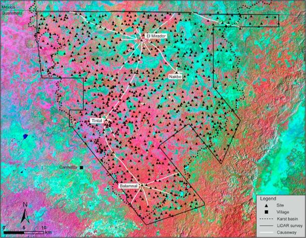
LiDAR technology of Maya site has revealed nearly 1,000 settlements hidden beneath the rainforest in Guatemala. (Hansen et. al - Cambridge University Press / CC BY 4.0)
Evidence of Advanced Society Revealed by LiDAR Technology at Maya Site
Light detection and ranging aerial scanning technology, with its remote sensing pulsed-laser mechanism, is able to penetrate through the densest of ecosystems and vegetation. The laser light bounces off surfaces to create a digitally reconstructed map, based on the time taken by the pulses to return to a receiver. Some of these LiDAR finds in the Central American rainforests have revealed vital details and information about the sheer sophistication of urban Maya society.
- Astonishing Scale of Ancient Maya Metropolis Revealed by Laser Scans
- Laser Scans Reveal 60,000 Previously Unknown Maya Structures Hidden in Guatemalan Jungle!
These finds, published in the December 2022 edition of the research journal Ancient Mesoamerica, reveal a site hidden below a rainforest which dates to the Middle (1000 to 400 BC) and Late (400 BC to 250 AD) Preclassic period. This time frame is contemporaneous with the sack of the ancient Elamite capital of Susa by Assyria, the destruction of the Temple of Solomon by the Babylonians, and the Greco-Persian Wars.
Several large platforms and pyramids, along with canals and reservoirs used for water collection, are part of the discovery by renowned historians and geologists, including those from the Universidad de San Carlos in Guatemala. “Many of these settlements demonstrate a political/social/geographical relationship with other nearby settlements, which has resulted in the consolidation into at least 417 ancient cities, towns, and villages with identifiable site boundaries,” write the researchers in the paper.
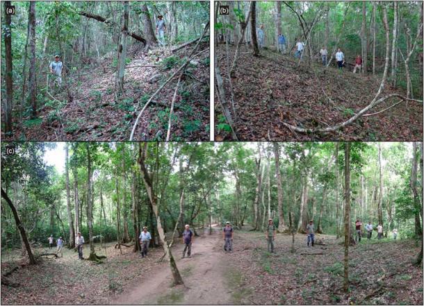
Photographs of MCKB inter-site causeways revealed thanks to LiDAR scans of the Maya site in Guatemala. (Hansen et. al - Cambridge University Press / CC BY 4.0)
Why the Did Maya Settle Here?
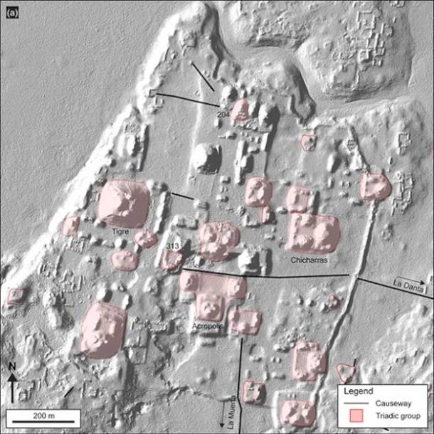
The densely packed Maya settlements in and around the Mirador-Calakmul Karst Basin (MCKB) has shown that some of these buildings packed residential homes, sports courts, religious, ceremonial and civic centers, along with the aforementioned networks of causeways and canals that linked these together.
The MCKB had the ideal balance of uplands for settlement, as well as lowlands for agriculture. The uplands contained limestone, the primary core of the building material, and enough dry land to live on. The lowlands, seasonal swamps called bajos, were spaces where wetland agriculture and terraced agriculture could be practiced, owing to the sheer fertility of the soil.
These settlements were built for the proverbial rainy day, as the Maya were believed to be experts in mitigating times of drought and flood and their architecture and constructional ideology displayed this. In all probability this is indication of a centralized kingdom-like state, revealing a sense of shared common identity and socio-political ideology. “When I generated the first bare-earth models of the ancient city of El Mirador, I was blown away,” explained Morales-Aguilar when discussing the Maya site. “It was fascinating to observe for the first time the large number of reservoirs, monumental pyramids, terraces, residential areas and small mounds.”
LiDAR scans of the Maya site have revealed a complex network of settlements and causeways hidden under the Guatemalan rainforest. (Hansen et. al - Cambridge University Press / CC BY 4.0)
Maya Site Reveals Massive Mobilization of Labor
The LiDAR analysis showed “for the first time an area that was integrated politically and economically, and never seen before in other places in the Western Hemisphere,” study co-author Carlos Morales-Aguilar, a postdoctoral fellow in the Department of Geography and the Environment at the University of Texas at Austin, told Live Science by email. “We can now see the entire landscape of the Maya region” in this section of Guatemala, he added.
The vastness of the Maya site and the sophistication of its architecture would have required the mass mobilization of labor and workers, including specialists. Specialists would include those in the pre-industrial assembly line of production, such as lime producers, mortar and quarry specialists, lithic technicians, architects, and legal enforcement and religious officials, according to a press release published on Science Alert.
This is also corroborated by the consistency in architectural forms and patterns, ceramic ware, sculptures, apart from the unified causeway constructions. Analysis of the Maya site reveals that centralized political, social, and economic solidarity existed among the occupants. The researchers wrote that this likely culminated into the coalescing of 417 ancient cities, towns, and villages, which had “identifiable site boundaries.”
- Aerial Survey Reveals Hundreds of Olmec and Maya Sites in Mexico
- El Mirador, ‘The Look Out’ Of Guatemala Boasts Probably the Largest Pyramid in the World
Over the past four decades, traditional excavations revealed 56 sites in the MCKB, including the lost city of El Mirador, which contains the largest stone pyramid in the history of the Maya, La Danta, discovered to date. Larger than the Great Pyramid of Giza, it likely required anything between 6 and 10 million days of labor and was built using 205,506 limestone blocks.
“Collectively, we argue that the development of infrastructure demonstrates the presence of complex societies with strong levels of socio-economic organization and political power during the Middle and Late Preclassic periods,” conclude the researchers when discussing the Maya site.
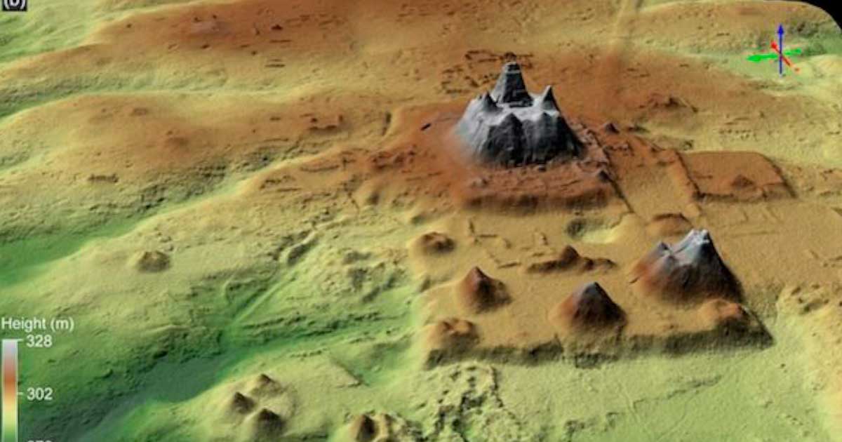
Top image: Complex of pyramids identified at Maya site using LiDAR technology. Source: Hansen et. al - Cambridge University Press / CC BY 4.0
By Sahir Pandey
References
Haf, F. 2023. “Lasers reveal 650-square-mile ancient Mayan city hidden beneath Guatemala rainforest” in The Daily Mail. Available at: https://www.dailymail.co.uk/news/article-11629075/Lasers-reveal-650-square-mile-ancient-Mayan-city-hidden-beneath-Guatemala-rainforest.html
Hansen, R.D. 2023. “LiDAR analyses in the contiguous Mirador-Calakmul Karst Basin, Guatemala: an introduction to new perspectives on regional early Maya socioeconomic and political organization” in Ancient Mesoamerica, 1. Available at: https://doi.org/10.1017/S0956536122000244
Nalewicki, J. 11 January 2023. “Lasers reveal massive, 650-square-mile Maya site hidden beneath Guatemalan rainforest” in Live Science. Available at: https://www.livescience.com/lidar-maya-civilization-guatemala
Nield, D. 15 January 2023. “Scientists Have Discovered Almost 1,000 Long-Hidden Maya Settlements in Guatemala” in Science Alert. Available at: https://www.sciencealert.com/scientists-have-discovered-almost-1000-long-hidden-maya-settlements-in-guatemala
Sankaran, V. 12 January 2023. “Ancient Mayan city discovered beneath Guatemala rainforest” in The Independent. Available at: https://www.independent.co.uk/news/science/guatemala-rainforest-mayan-site-airplane-survey-b2260680.html

Comments
No, just coffee, as my morning-fix daily commentary should suggest. But as for mind killing drugs, or just plain silliness, you might want to talk to the ‘master-minds’ behind the prevailing/pervading lunacy: Wow, here’s a real doozy- https://www.ancient-origins.net/news-history-archaeology/mortuary-0014888 I guess anything goes ...except thinking it through, and making it add up. But let’s ALWAYS ask, would people (then or now) really do that? ...Sorry, all, who may be caught off guard and have their old nonsensical paradigms come crashing down around them; but time’s do change. But people are still people, and coffee still hits us, and corners still get turned. No joke!
PS: Oh, I see you removed the LSD reference from your comment. Dang. But maybe one day I’ll try a hit of that, maybe SEE further down into the nature of our condition here on this poor planet.
Nobody gets paid to tell the truth.
Seriously Pete?
Something that size would NOT just be abandoned. The only plausible explanation is that the people were wiped out fairly suddenly, and the place was thereafter left to nature. The dating MUST be wrong. I’d guess it was an Atlantean era culture that succumbed at the same time as Atlantis (circa 115k BC, adding the zero back to Plato's timeline). But think about the modern weather pattern, where the sands of the Sahara travel in that direction. Nuclear fall-out would explain the sudden demise. What else does?
Nobody gets paid to tell the truth.