
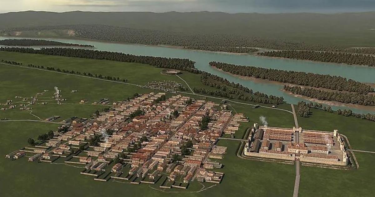

An entire Roman town—not merely a fort—has emerged from beneath fields at Stein in Lower Austria. The University of Innsbruck says geophysical mapping reveals a 25–30-hectare street grid and an amphitheater estimated to seat 8,000, remarkably ambitious beside a garrison of about 500 soldiers. Vienna.at reported it might be the elusive Claudivium named by Ptolemy, but that identification remains unproved. Why did this lost Roman city empty after roughly a century?
A City Mapped Without Digging
The Roman past of Stein is somewhat known due to the discoveries made in earlier surveys. In fact, ArchaeoPublica conducted a survey in 2017–2018 that revealed the existence of fortifications as well as traces of civilian streets. In 2025, Mario Wallner and colleagues published a paper that provided additional magnetic and ground-penetrating radar evidence that allowed them to establish a more comprehensive urban map. The team used magnetometry in a survey covering roughly 100 hectares and ground radar on 50 hectares of the site. As earlier Roman-town radar work covered by Ancient Origins shows, a street plan can be read even where little is visible above ground.
- Gladiator School Discovery Reveals Hard Lives of Ancient Warriors
- Researchers Discover Gladiator Fans Had Souvenirs, Fast Food, and Fresh-Baked Treats at Their Fingertips
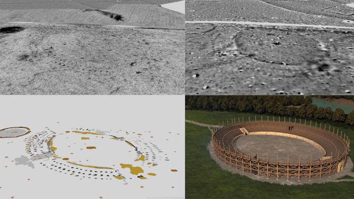
Magnetic and radar scans have revealed the amphitheater. (University of Innsbruck)
At Stein, the straight streets divide blocks aligned with the auxiliary fort, while graveyards can be found on the roads leading away from the settlement. Gerald Grabherr, archaeologist from Innsbruck, estimates that the newly detected arena was similar in size to an amphitheater in Carnuntum, another center of Roman civilization located at the Danube River, offering 8,000 spectators as a capacity estimate. He explains that a planned town this large next to a fort housing little more than 500 soldiers is unparalleled in the Roman record.
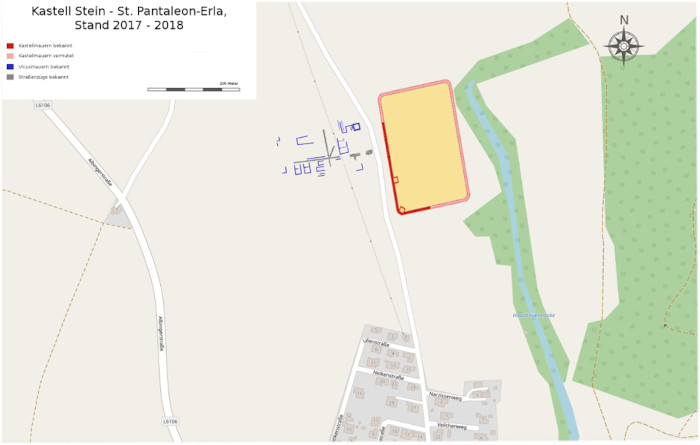
Sketch of the auxiliary fort at Stein based on the 2017–18 findings, not the newly mapped full city. (© OpenStreetMap contributors, edited by Veleius CC BY 3.0)
A Frontier City at a Crossroads
The rivers are significant in understanding the site. According to the researchers in Innsbruck, a timber-and-earth camp dating back to the first century and a stone fort that was built later protected a Danube crossing located near the mouth of the Aist, while the valley provided a convenient access point towards the Vltava, which is beyond the Roman territory.
Earlier research performed by ArchaeoPublica identified the location of a fort that was not extensively rebuilt upon, as opposed an untouched landscape. Its report also records six military diplomas from Stein. Finding these bronze certificates of service show the army's presence, although unfortunately they do not reveal the town's name.
- Austria’s Mysterious “Desolate Castle” Finally Identified—It Was a Roman Fort!
- Newly Discovered Roman Camp Sheds Light on Marcus Aurelius' Campaigns
According to the research, the areas north of Danube seem to have been occupied by 3 or 4 Roman camps, indicating a larger concentration of military presence. Ptolemy's second-century description for a settlement called Claudivium included a river joining from the north, which fits both Stein and the Aist. But there is no material evidence such as an inscription found to back up this assertion, leaving the town being identified as Claudivium still only theoretical.
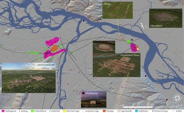
Map of the Roman settlement landscape between Enns and St. Pantaleon-Erla: In the west Lauriacum Enns, further east possibly Claudivium/Stein south of the confluence of the Aist with the Danube. In addition, several watchtowers have already been proven in the area and (temporary) Roman camps north of the Danube. (University of Innsbruck)
Why the Settlement Emptied Out
Coins indicate that the settlement went out of use at about AD 180, near to the death of Marcus Aurelius and the conclusion of the Marcomannic Wars under Commodus. The researchers speculate that the forces of Rome moved from Stein to Lauriacum, present-day Enns. According to Barbara Kainrath, an archaeologist, there is no evidence of devastation but rather of a systematic withdrawal. Similar brooches and tools for bronze casting found at Lauriacum suggest that some craftsmen relocated from Stein, notes the report.
That does not prove every family moved, or that an imperial order alone caused the departure. The Danube frontier could be violent—Ancient Origins reported a Roman mass grave in Vienna—but evidence of that kind of violence does not appear at the Stein site. So explaining precisely what ended this abandoned Roman city awaits further investigation.
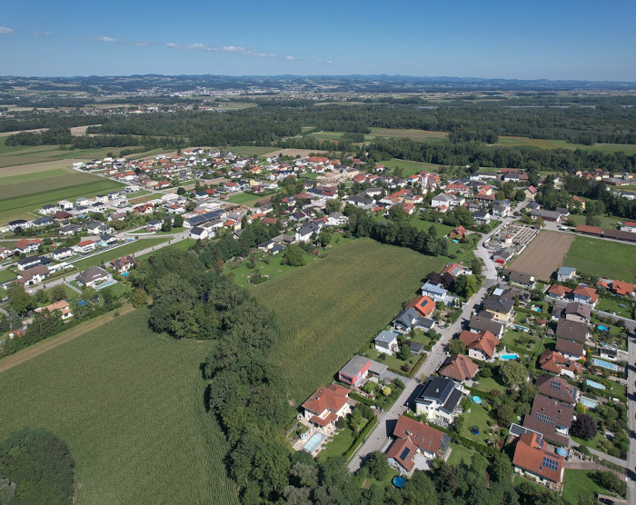
Modern Sankt Pantaleon in the municipality where Stein lies; this photograph does not show the buried city itself. (Hans Koberger/CC BY-SA 4.0)
An Archaeological Record at Risk
The apparent absence of subsequent development gives a rare glimpse into Roman planning, with the caveat that plowing and other farming practices could have erased evidence. ORF Niederösterreich warns that agriculture could still wipe out relevant data, unless appropriate conservation and research measures are undertaken.
Although the western Danube Limes area is a UNESCO World Heritage site, the new discoveries are not included in the list of World Heritage sites yet but might become a part of it in the future. Further investigations will help to unite Stein, its fort, and the nearby Lauriacum.
Top image: Aerial view reconstruction of how the Rfoman town would have appeared. Source: GeoSphere Austria/University of Innsbruck
By Gary Manners
References
ArchaeoPublica. n.d. Geophysik und Survey Stein – St. Pantaleon. Available at: https://www.archaeopublica.eu/verein/projekte/survey-sankt-pantaleon/
ORF Niederösterreich. 2026. Straßen und Amphitheater: Römische Stadt entdeckt. Available at: https://noe.orf.at/stories/3372363/
UNESCO World Heritage Centre. n.d. Frontiers of the Roman Empire – The Danube Limes (Western Segment ). Available at: https://whc.unesco.org/en/list/1608/
Universität Innsbruck. 2026. Die vergessene Stadt: Roms Netzwerk beiderseits der Enns. Available at: https://www.uibk.ac.at/de/newsroom/2026/die-vergessene-stadt-roms-netzwerk-beiderseits-der-enns/
Vienna.at Redaktion. 2026. 2,000 Years Hidden: Researchers Discover Roman City in Lower Austria. Available at: https://www.vienna.at/2000-years-hidden-researchers-discover-roman-city-in-lower-austria/10493108
Wallner, M., et al. 2025. Claudivium? – How to discover a new Roman town? ArcheoSciences 49(1 ), 219–222. Presses universitaires de Rennes. Available at: https://shs.cairn.info/revue-archeosciences-2025-1-page-219?lang=en