


Hato Caves –Shelter of the Rebellious Slaves of Curaçao
Caves and cave systems have an enduring fascination for us and are to be found all over the world. While some still remain undiscovered or closely guarded secrets, many are open to the public and draw us in to their shadowy beauty.
One of the most interesting cave systems in all of the Caribbean is the Hato Caves, situated on the beautiful island of Curaçao. They are one of the main tourist attractions on the vacation-island, which is otherwise famous for the orange-flavored liqueur by the same name, their Aloe Vera products, and Dutch Cheese.
The History of Curaçao
In the Southern Caribbean, in the Lesser Antilles, Curaçao lies about 60 miles (100 km) off the South American mainland. It is a self-governing island and part of the Kingdom of the Netherlands, although the Arawak people first settled on the island several thousand years ago.
The Spanish took control of the island in the 16 th century and the majority of the indigenous population died due to disease and harsh repression. Possession of the island changed hands several times, and was occupied successively by the Spanish, the British, and the Dutch, who finally gained control of Curaçao in 1815 after seizing the island during their 80-year war of independence with Spain.

Arawak people gathered for an audience with the Dutch Governor, 1880 (Tropenmuseum / CC BY-SA 3.0)
They colonized the island which became a center of mining and sugar production. Slavery was abolished in the 1860s and today Curaçao is a popular tourist destination because of its incredible beauty.
History of the Hato Caves
The caves are quite unique in that they are above ground, and therefore were used by the first people of the island, the Arawak, at least two millennia ago. While it has been suggested that they may have lived in the caverns, they undoubtably made good use of them and left many artifacts as well as some primitive rock art at the site.
About 1500 years ago, the Caiquetio Indians from northern Venezuela appear to have used the cave system, possibly for ritual purposes. Both the Arawaks and the Caiquetio Indians used the Hato Caves as a burial site.
The caves fell into disuse after the arrivals of the Spanish Conquistadors in the 16 th century which afforded run-away slaves, who had escaped from plantations and mines in the 18 th and 19 th century, a safe place to hide. During the many slave revolts on Curaçao, the site was also used by rebellious slaves.
- A Brief History of a Dutch Island - Manhattan
- Krubera Cave - Journeying to the Depths of Georgia in One of the World’s Deepest Caves
- Tulum: Maya City of the Dawning Sun, a Caribbean Paradise

Commemorating the slave revolt of Curaçao 1975 (CC BY-SA 2.0)
The Hato cave system was opened to the public in the 1990s and are now considered to be show caves since they have been adapted to meet the needs of tourists.
What To See In Hato Caves?
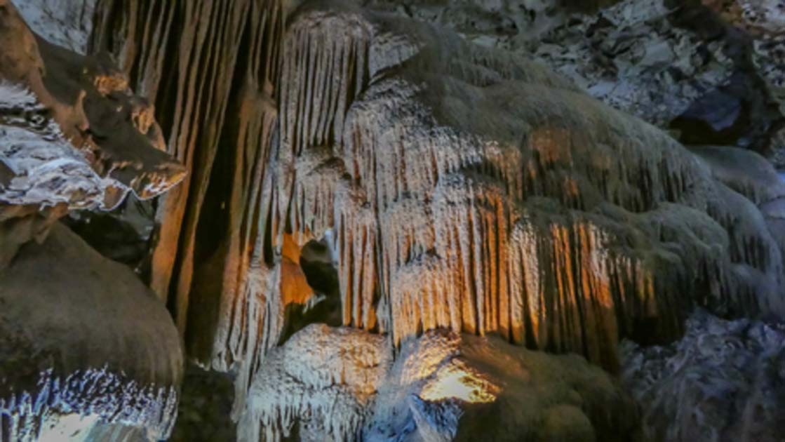
The caves were originally coral and are approximately 300,000 million years old. When the sea levels fell during Ice Ages, these coral limestone reefs were left exposed and subjected to the karstic process - when water and the elements dissolve the limestone - which resulted in the remarkable features on the system including its many stalactite, stalagmite and rock formations.

Stalactites of the Hato caves (Public Domain)
The caves are about 800 feet (250 m) long and they cover an area of some 52,000 ft2 (5000 m2). The system consists of three tiers or levels with caves on the second tier. Unlike many similar systems, the Hato system is warm since it is above ground. A large waterfall is hidden within and several large sinkholes, one quite large and filled with water, are popular attractions.
Many visitors head straight for the famous statue of the Madonna nestled inside the caves, while others hope for a sighting of the rare species of long-nosed fruit bats to be found in the cavern. There are some pictographs and rather mysterious rock art at the site. Experts have been unable to decipher or date these intricate designs which may have been symbols used by ancient shamans.
How to Get to Hato Caves
The caves are located on the north side of the island, close to Curaçao’s International Airport. The system is also not far from the beautiful capital of the island, Willemstad. An admission fee is charged, and guided tours are available at an extra cost. The caves are easily accessible as the path winds along through the system, past all the fantastic formations and traverses some of the sinkholes and pools of waters.

The start of the Indian Trail, Hato Caves, Curaçao (CC BY 2.0)
Outside the caves, an ancient Indian trail leads visitors in the footsteps of the original Amerindian inhabitants to witness some of the remaining rock-art.
Top image: Hato Cave Source: CC BY 2.0
By Ed Whelan
References
Lace, M. J., & Mylroie, J. E. (2013). Coastal cave and karst resource management. In Coastal karst landforms (pp. 127-143). Springer, Dordrecht
Available at: https://link.springer.com/chapter/10.1007/978-94-007-5016-6_6
Lace, M. J., & Mylroie, J. E. (2013). The Biological and Archaeological Significance of Coastal Caves and Karst Features. In Coastal Karst Landforms (pp. 111-126). Springer, Dordrecht
Available at: https://link.springer.com/chapter/10.1007/978-94-007-5016-6_5
Kraan, C., et al (2017). New Archaeological Research on Curaçao. The Journal of Island and Coastal Archaeology, 12(1), 138-144
Available at: https://www.tandfonline.com/doi/abs/10.1080/15564894.2016.1253629
