


What Did Ancient Civilizations Believe Lay at The Edges of the Earth?
The first civilizations didn’t have satellites in the sky, mapping every inch of the world in real time. They only knew the parts of the world they’d seen. Everything beyond that, they had to imagine.
It made the world a stranger, more magical place. They saw their own homes at the center of a disc-like planet, surrounded by a threshold that would them into a world of magic that lay on the edges of the earth.
There are a handful of ancient world maps and encyclopedias that let us know how they saw that world. The Babylonians, the Greeks, and the Romans all left behind their own visions of our world and its furthest thresholds, each one giving a glimpse into how they saw the world and imagined the farthest reaches, or edges of the earth.

A Byzantine Greek world map according to Ptolemy's first (conic) projection. From Codex Vaticanus Urbinas Graecus 82, Constantinople c. 1300. (Public Domain)
The Babylonians: The Seven Outer Regions
The oldest world map ever found was made in Babylon. It shows the world as a round disc surrounded by an ocean of bitter waters. On the edges of the earth, beyond the ocean, they believed, were seven strange lands full of magic and monsters.
- Hereford Mappa Mundi: Legendary Cities, Monstrous Races, and Curious Beasts in a Single World Map
- The Turin Papyrus: The Oldest Topographical and Geological Egyptian Map
- The Babylonian map of the world sheds light on ancient perspectives
The map was made in the 7th or 6th century BC, but its ideas are even older. The notes left by the engraver say that it was copied from a tablet made 200 years earlier, but the idea’s probably even older than that. One of the outer worlds on that map shows up in the Epic of Gilgamesh, written in 2100 BC.
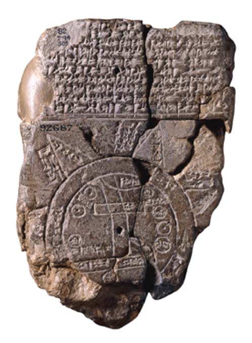
6th century BC map showing Assyria, Babylonia and Armenia. (Public Domain)
The outer regions are shaped like triangles. This, the Babylonians believed, was how they would appear when approached from the sea: like great expanses of land that get narrower and narrower as they go, the edges of the land falling off into endless space.
Only a handful of their descriptions survive, but every one suggests they are mystical and unreachable places. One is labeled the place “where the winged bird ends not his flight”, meaning a place that no bird can reach. Another, the map warns, is home to a horned bull that attacks anyone who lands there.

One is labeled the place “where the winged bird ends not his flight.” (CC0)
An island in the north, they believed, was enshrouded in complete darkness. Another, just a little to the west of it, was a place where the light was brighter than any star.
The Greeks: The Lands Of Monsters
The early Greeks, before Pythagoras first proposed that our world is round, had a very different idea about what our world looked like. They believed that the world was a disc; a series of concentric circles with Athens in the center.
Their own home, they believed, was a near-perfect circle, surrounded by a perfectly circular Mediterranean Sea. Africa, Europe, and Asia circled perfectly around that sea. And if one traveled far enough to reach the ends of one of the foreign continents, they would find nothing but an endless ocean.

‘The Ninth Wave’ (1850) by Ivan Aivazovsky. (Public Domain) Many of the ancient Greeks believed if one traveled far enough to reach the ends of one of the foreign continents, they would find nothing but an endless ocean.
For them, Athens was more than just the geographical center of the world – it was the center of civilization, as well. The further one traveled toward the edges of the earth, the more savage the land and the people would become, and the more monsters they would find.
Even as the Greeks started to get a better grasp of the outside world, they still accepted the idea that it was a disc with monsters on the edges. When the Greek explorer Ctesias came back from India, he insisted he’d seen people with dog’s heads, tigers with humans faces, and people with gigantic feet they used as parasols.

Among the more absurd claims of Ctesias’ ‘Indica’ were the stories of a race of people with only one leg, or with feet so big they could be used as an umbrella. This is an example of such a creature in the Nuremberg Chronicle. (Public Domain)
India, they believed, was one of the ends of the earth. Herodotus wrote that India was the furthest east anyone could travel and that Arabia was the furthest point in the south. But the north and the west, he believed, were a still an uncharted mystery:
“I have never found anyone who could give me firsthand information of the existence of a sea beyond Europe to the north and west.”
The Romans: The Low Countries
The Greek concept of the world didn’t totally go away. Even after Pythagoras and Aristotle suggested that the world might be a sphere, many still seem to have held on to the idea that there was an edge to the earth filled with savages.
Julius Caesar, himself, was convinced that Rome was the center of the world. The further out you traveled, he believed, the more savage the people would become.

Map of the world according to Strabo. (Public Domain)
It wasn’t altogether different from how the Greeks saw the world, except that, for the Romans, the northern and western extremities of the world were no longer uncharted lands. They had marched their armies right into what they believed was the edge of the world.
The northern edges, they believe, were overrun with floods. Pliny the Elder, who had visited the Chauci people who lived in north-west Germany, reported back:
“There, twice in every twenty-four hours, the ocean's vast tide sweeps in a flood over a large stretch of land and hides … There these wretched peoples occupy high ground … when the tide has receded they are like shipwrecked victims.”
- The Buache Map: A Controversial Map That Shows Antarctica Without Ice
- Cartographic Comedy in the 16th century: The Fool’s Cap Map of the World
- The Ancient Civilizations that Came Before: Self-Eradication, Or Natural Cataclysm? – Part I
The Romans soon became convinced that all the outskirts of the northern world were the same. They were full of wild forests and marshes where savage men lived, constantly bombarded by the crash of the rising tides.
It was a small hint of truth expanded into a lie. They’d seen one part of Germany that was below the sea level and told themselves that this was simply what the whole world looked like outside of their own domain.

Roman bronze figure, discovered in the National Library in Paris, France, in the late 19th century. The Germanis is wearing a typical suebian knot hairstyle and a characteristic cloak. Bibliothèque Nationale de France Paris, Cabinet des Bédailles Paris, Inventory No. 915. Dating to 2nd half 1st century to 1st half 2nd century AD. (Bullenwächter/CC BY 3.0)
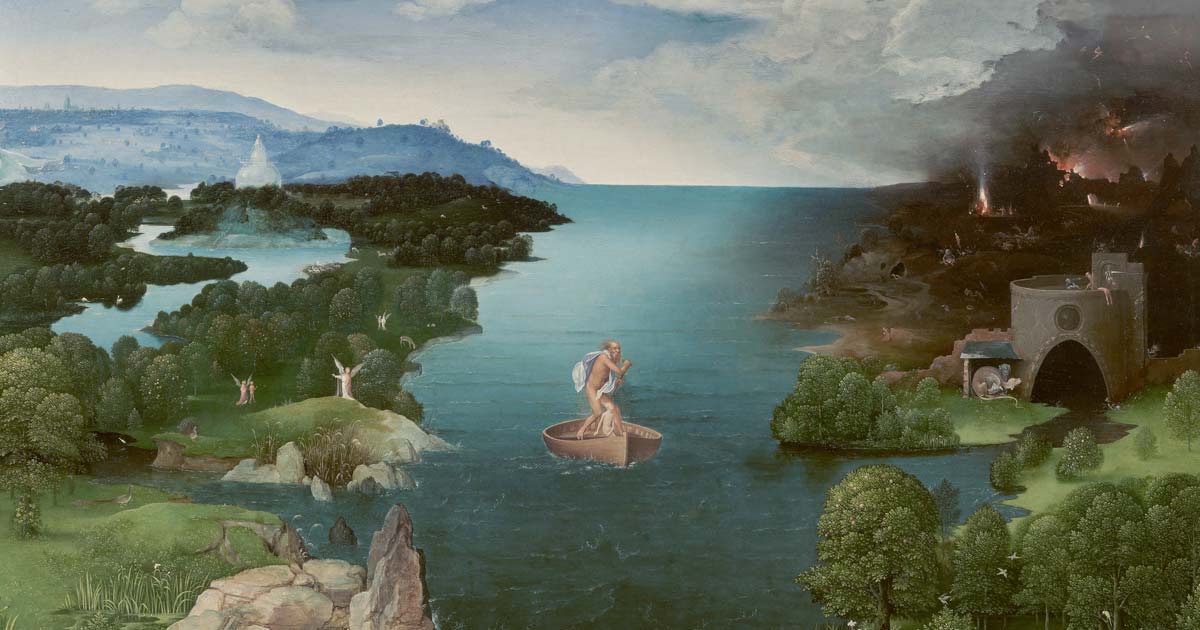
Top Image: ‘Crossing the River Styx’ (circa 1520-1524) by Joachim Patinir. Many ancient people imagined the edges of the earth as strange and magical places. Source: Public Domain
By Mark Oliver
Resources
Lendering, Jona. “The Edges of the Earth.” Livius. April 2, 2018. Web. http://www.livius.org/articles/concept/the-edges-of-the-earth-1/
Pliny the Elder. Natural History. Trans. John F. Healy. Penguin Books, 2004.
Romm, James S. The Edges of the Earth in Ancient Thought. Princeton University Press, 1994.
Siebold, Jim. “Babylonian World Map.” Cartographic Images. July 22, 2015. http://cartographic-images.net/Cartographic_Images/103_Babylonian_World.htm

Comments
Only the most backwoods of cultures ever thought that the Earth was flat. Before the end of the Ice Age, there was a worldwide network of trading seaports. Anyone who had ever seen a ship sail over the horizon knew that the world was round, with a line of sight of @ 50 miles to the horizon. The ancient Egyptians calculated the circumference, and their cubit was based upon it. This fact assumes a recognition of gravity, long before the Eurocentric historians claimed Newton.The people whom the Greeks called "Scythians" kept the secrets of open sea navigation for thousands of years.