


From the Vikings to WWII, the Danevirke Wall Has Seen it All
All through classical history, imposing and long walls, ramparts, and fortifications played a significant role in securing the borders of nations and kingdoms from all sorts of incursions and attacks. Some of the best examples are left to us by the ancient Romans, with their majestic limes fortifications of Europe, and the Antonine and Hadrian’s Wall in Scotland. Then there is the famous inspiring Great Wall of China, the likes of which were never replicated again.
But no matter where they were, these fortified walls and ramparts were always a great achievement. They required a lot of manpower, took a long time to erect, and were costly. But all of that was worth it - for such a wall could help guard a great area of land, making for an effective and immovable border. One such system of walled fortifications is known as the Danevirke, a lesser known, but equally important historical system of earth wall ramparts built by the Danes on the southern end of the Jutland Peninsula. Join us as we explore the complex history behind this important border!
The Earliest Traces of Danevirke in the Nordic Iron Age
The Danevirke, in Old Norse known as Danavirki, and in German as Danewerk, is today located not in Denmark, but in Germany, in the state of Schleswig-Holstein. It is believed that the earliest forms of a linear walled fortification across the neck of the Jutland Peninsula began sometime prior to 500 AD, in the Nordic Iron Age.
Afterwards it was gradually expanded and built upon, most actively during the Danish Viking Age, around 800 AD and onwards. These walls stretch across the peninsula and measure around 30 kilometers (19 mi). Important to note is that they are mostly in sections, and that the inhospitable terrain of the Jutland Peninsula provides the additional safety against incursions.

Shot of the Danevirke in the modern day. (Image: Willi Kramer / CC BY-SA 3.0 DE)
During the early 1970s, extensive archaeological research, centered on the methods of dendrochronology, which based the age of the wall on tree rings - came to a conclusion that the Danevirke was for the most part, built in three separate stages, from 747 to 968 AD. Furthermore, complex radiocarbon dating concluded that the earliest layers of the ramparts predate 500 AD, suggesting a much earlier origin.
One interesting theory that concerns Danevirke is its original purpose. Some scientists agree that the early role of this wall was not military, but rather economical. It is speculated that the wall was initially a system of dykes and canals, a shipping shortcut between the North Sea and the Baltic. As such, it consisted of a canal with two raised embankments on each side, which would make it naturally easy to transform into a series of raised ramparts. A big clue to this aspect is its original name, coming from the Middle Danish language - Danaewirchi - “The Dyke of the Danes”.
As mentioned, the total length of the Danevirke system is 30 kilometers (19 mi). It consists of two major defense lines, the Danevirke and the Kovirke. The Danevirke is centered around its main, central portion, and the rest resulted from successive building and improvement. These ramparts defended the passable lowland portion of Jutland between the Firth of Schlei on its east side, and the River Treene on its west side.

The Danevirke (shown in red) on the 16th-century Carta Marina by Olaus Magnus, published in 1539. (Public domain)
The Kovirke on the other hand, was created as a single straight line across a flat plain. Its ramparts are 8 meters wide (26 ft) and 2 meters high (7 ft), with a frontal triangular ditch. It is believed that this was built by Harald Bluetooth.
The main, older system of ramparts, the Danevirke, is comprised of about 6 distinct portions. These are often classified simply as Danevirke 1, 2, 3, 4, 5, and 6, but each one has its own historical, regional names. The main Danevirke mentioned above consists of Holdvolden, Nordvolden, and Østervolden, i.e. the Main, North, and East Ramparts.
In its basic role, all of these walls combined served as a defense against incursions into Denmark from the Jutland Peninsula, and stretched from the Viking trading city of Hedeby on the Baltic, all the way to the untraversable marshlands on the west side. But who was on the other side of the Danevirke, and who was it that they wanted to keep out?

Shot of Danevirke 6 – ‘The Valdemar-wall’. (Szilas / CC0)
Keeping the Slavs and Saxons at Bay
To answer this question we need to take a good look at the history of this area of South Jutland, also known as Holstein. While Hedeby was indeed an important and large Viking trading center, it was also the southernmost of the Danish settlements, and south of it were the Saxons and the Slavs.
For centuries, the Slavic tribes inhabited the entire expanse of Central Europe, from the Baltic coasts, to the Elbe valleys, and all the way up to the lower Jutland Peninsula. Directly next opposite to them were the boundaries of the Saxons, with whom the Danes had a lasting conflict.

Depiction of Viking army in battle. (Peter Nicolai Arbo / Public domain)
To stop the incursions of the Saxons and the expanse of the many Slavic tribes, the Danes had to find an effective means of securing their borders, and they accomplished this with the use of this ingenious system of ramparts. And even though Hedeby was destroyed in 1066 by the Slavic tribes, and abandoned, the Danevirke wall fortifications remained as a guard of the borders and stayed in use well after it. And that shows us just how important a wall fortification can be in war time.
During the mid 1800s, Europe saw the emergence of national states, and this meant that the lower Jutland region, known as Schleswig (Schleswig-Holstein), became a center of attention for both the German and Danish peoples. The area was long contested between the two nations, with both appropriating it as part of their own sense of identity, with the Slavic tribes being expelled long ago and assimilated from their hearths.
Culturally and linguistically, the Danevirke still acted as a boundary between the two nations, in a way. Just south of it are Kiel and Lübeck, which were two important German towns of the Hanseatic League. But for the Danish people, lower Jutland was still a part of their own nation.

Danish soldiers return home to Copenhagen after the First Schleswig War. (Otto Bache / Public domain)
This rising tension escalated with two conflicts between Germany and Denmark, known as the First Schleswig War (1848-1851), and the Second Schleswig War (1864). This was the last military use of the Danevirke. And even then, it once again became an important site for the Danish nation, symbolizing their age-old boundary against Germany, and a unique symbol of their identity.
The Second Schleswig War and the Revival of the Ancient Wall
The Second Schleswig War of 1864 played a crucial role in the future of the Danevirke. During that decade from the onset of the First Schleswig war in 1848, the eyes of the entire Danish nation were focused on Danevirke. Besides being a strong national symbol, it was also the expected focal point of the war. The Danish military expected the brunt of the German attack to descend on the ramparts, and the chief battle to take place along it.

Danish soldiers in battle during the Second Schleswig War. (Vilhelm Rosenstand / Public domain)
After centuries of disuse, the Danevirke was somewhat “out of shape”, and required some additional work. The military of Denmark restored the weak parts, reinforced the ramparts and strengthened the key points. They also installed artillery positions on it – all in preparation of the coming attack. But when the Second Schleswig War started, the initial skirmishes were led south of the wall. What happened next took the Danish public by surprise, and the potentials of Danevirke were lost.
It was a full retreat, ordered by the Sephardic Supreme Commander of the Danish army, Christian Julius de Meza. Suspecting a major threat of a flanking maneuver by the Germans, De Meza ordered a retreat behind the Danevirke wall and to the north, abandoning the fortifications and the artillery in the process. This abandonment of such an effective defensive position, which was at the time relied upon by the entire Danish nation, came as a great shock to the public and the government. Julius de Meza was immediately relieved of his duties, and after this, the Danevirke was never again in Danish territory, and to this day remains in Germany. Still today, historians fiercely debate the decisions of de Meza.
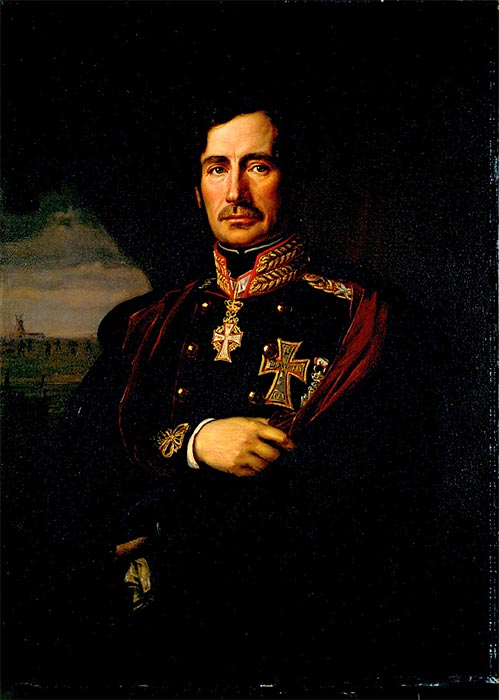
Sephardic Supreme Commander of the Danish army Second Schleswig War, Christian Julius de Meza. (August Schiøtt / Public domain)
Even though 1864 saw the last actual military use of the Danevirke wall, there was another chance of it seeing conflict and showing its military worth – and that was the Second World War. Even though the north of Germany and Denmark were somewhat exempt to the ravages of war, the German High Command still suspected an allied assault from the north, through Denmark. Thus they came up with an idea to utilize the ancient Danevirke walls as a means to hinder such an invasion, by reinforcing it and converting it into an anti-tank barrier. This was to be done by the Wehrmacht, and such an undertaking would surely destroy the Danevirke, or irreversibly change it from the original, ancient form.
The news of this came to the Danish archaeologist, Mr. Søren Telling, who simply couldn’t bear to see this ancient monument ruined. So, since all archaeological excavations in wartime Germany were under the direct jurisdiction of the SS, Mr. Telling decided to telephone the head of the archaeological department of the SS – known as “ Amt für Ahnenerbe” ("Office for Ancestral Heritage"), and then even Heinrich Himmler himself.
The Danish archaeologist presented strong points, and pleaded against the creation of the barriers, telling Himmler that in the process an important heritage of the Aryan Civilization would be lost. Heinrich Himmler understood the situation and accepted to cancel the constructions, and leave Danevirke in peace. Since his command ruled over that of Wehrmacht, he ordered the immediate canceling of all operations related to Danevirke. Mr. Telling remained a custodian of this historic site well after the war and until his death in 1968.
The Land of Walls
Danevirke is not the only fortified wall of its kind in Europe. Throughout history, many nations found walls and high ramparts as the only effective means of withstanding a large attack, especially during the Iron Age. The Slavs of Central Europe and Polabia – today’s Germany – were well known for erecting massive ramparts and earth work walls, some of which took many men to raise. Many such walls and circular enclosures dot the German countryside today, still resisting the passage of time.
An important example akin to Danevirke are the Silesian Walls (Wały Śląskie), which can be found in Southern Poland, in area known as Lower Silesia. These parallel walls and ramparts were erected in the 15 th century or before, and run for 30 kilometers (19 mi), between the important towns of Szprotawa and Kożuchów. They are 2.5 meters (8.2 ft) tall and 47 meters (154 ft) at the widest point. They are believed to have been an important border of the historic Duchy of Głogów.
Another very important ancient earthen wall is the well-known Offa’s Dyke ( Clawdd Offa in Welsh), that follows roughly the modern border between England and Wales. At the time of its construction and later, it signified the border between the Anglian Mercia, and Welsh Kingdom of Powys. It is widely believed that the original construction was ordered by the Anglo-Saxon King Offa, who ruled as King of Mercia from 757 to 796 AD.

Part of Offa’s Dyke near to the English-Welsh border. (ultraBobban / CC BY-NC 2.0)
This immensely important historical earth wall is one of the great achievements of early medieval Europe, and its length is an astonishing accomplishment – it runs for roughly 240 kilometers (150 miles)! And it also shows us that earth work walls and defensive ramparts such as the Danevirke, were certainly a popular and effective means of defending borders, and were favored by many European rulers.
- With Portals to the Dead, Viking Homes Were Stranger Than Fiction
- Viking Camp Complete with Ship Building and Weapon Workshops Unearthed in England
- Was It Just a Boss Spying on His Workers? First Viking Age Tower Found in Denmark
The Watchers on the Wall
The Danevirke walls remain a crucial insight into the intriguing history of the Jutland Peninsula and Schleswig-Holstein, being a telltale sign of its varied history and many nations that came to call it home. And though it is considered a part of Danish heritage and identity, a lasting remnant of their proud Viking history, today the Danevirke is sadly in German territory. What remains to be seen is how these earthen walls and ramparts will face the test of time, and how archaeologists can further piece together the puzzle of its origins, creation, and original purpose. Time will tell!
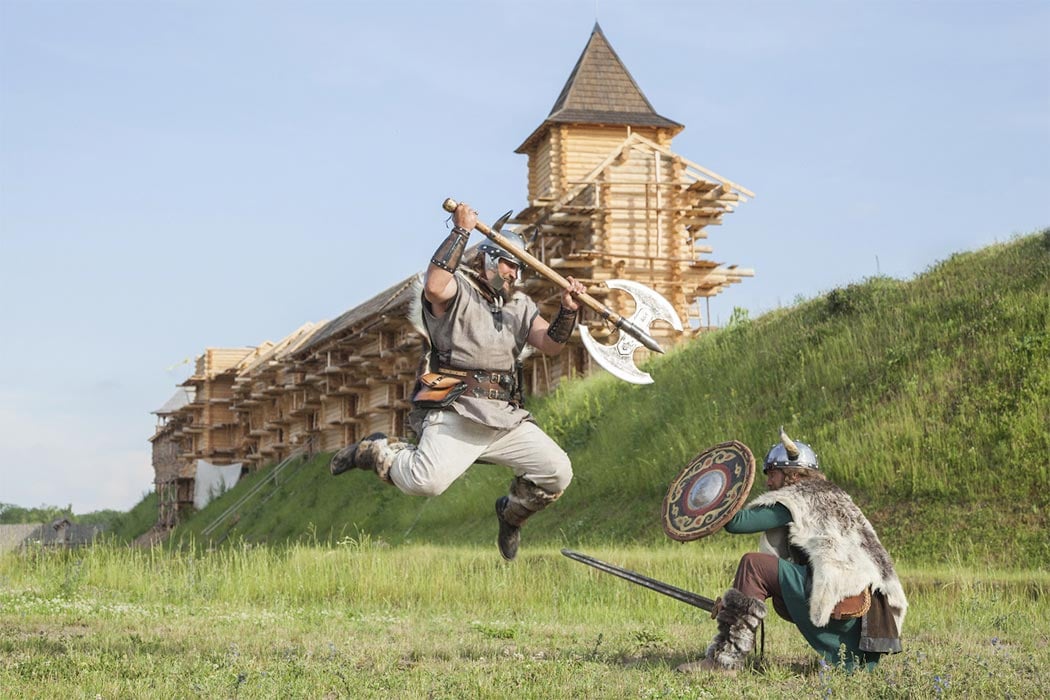
Top image: Danevirke wall defended the Danes in the north from the Germanic and Slav tribes. Source: khosrork / Adobe Stock
References
Crabtree, P. 2017. Routledge Revivals: Medieval Archaeology (2001). Taylor & Francis.
Pulsiano, P. 1993. Medieval Scandinavia: An Encyclopedia. Taylor & Francis.
Spring, P. 2015. Great Walls & Linear Barriers. Pen and Sword.
