


Nauru, The Tiny Nation with a Blackened Name
One of the many micro-nations in the Pacific is Nauru, once known as Pleasant Island. This small island has a rich and complex history. It is the third-smallest country in the world and, at one point in history, its inhabitants were among the wealthiest in the world. Now, the tiny nation faces an uncertain future, damaged by climate change, environmental degradation and a blackened name. Today, it is steeped in controversy for being Australia’s dumping ground for refugees.
Geography of Nauru
Nauru is north-east of Papua New Guinea in the South-East Pacific and is located just south of the equator. The country consists of one island that is 8 square miles (12 miles square). It is almost encircled by a coral reef and this means, that there is no natural harbor on Nauru.

Location of Nauru, Pacific Ocean (Google Maps)
There is very little fertile land and water is scarce. Nauru is regarded as being part of Oceania geographically. The capital and largest settlement is Denigomodu. Approximately 10,000 people live on the island.
History of Nauru
Based on the archaeological record, the island was first settled by Melanesians about 3000 years ago. There was a later settlement of a proto-Polynesian people who belong to the Lapita culture. The island was dominated by twelve clans who were led by chiefs and councils of elders. Clan warfare and territorial disputes were common, and the majority of people lived by fishing and harvesting coconuts. At an unknown date, the island became a kingdom.

The area covered by the Lapita travels (Britannica)
From the late 18th century the Nauruan’s came into contact with Europeans, mainly the crews of whalers. This contact began to destabilize traditional society and introduced new diseases such as leprosy. Many shipwrecked sailors and deserters came to live on Nauru, their presence and the introduction of firearms were particularly destabilizing. The island was devasted by a ten-year war from 1878 to 1888 as two rivals vied for the throne of Nauru. This war ended when the Germans intervened and added the island to their Pacific properties. The island was part of the German Empire until 1914 when the Australians invaded the island and it was later administered by the British.
During the Spanish Flu Epidemic (1918-20) almost one in five of the population died.

One of the many emergency hospitals during the Spanish Flu pandemic (CC BY 2.0)
When phosphate was discovered on the island it led to a growing mining industry which attracted migrants from other parts of Oceania. In 1940 German warships attacked the island and its phosphate mines and facilities. This led to a shortage of raw material for the Australian war effort.
The Japanese occupied the island during WWII until 1945. They abused many human rights and deported men to work as slave laborers on distant islands. After the war the island was under the control of the United Nations and it was once again administered by the British. The island became independent in 1968.
The price of phosphates increased in the 1970s and the island experienced an economic boom for a brief few years, with the Nauruans becoming affluent. However, when the phosphate mines became less productive the economy almost collapsed. Unemployment was widespread and the environment was polluted because of the mining.
- Bananas Helped Ancient Lapita Culture Colonize Oceania
- Tristan da Cunha: Only 269 People Remain on World's Most Remote Inhabited Island
- Cannibal Jack Jones and the Beachcombers of Samoa

Location of the immigration detention center and phosphate mines, Nauru (Google Maps)
The controversy caused by Australia using Nauru to detain asylum seekers who attempted to enter illegally has led the international community to raise concerns about the welfare of the migrants and their rights in recent years. The island is also regarded as a tax-haven and has come under pressure from the USA to end its lax oversight of the banking system.
Landmarks of Nauru
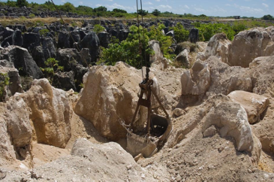
The central plateau of the island is a moonscape caused by phosphate mining. The mines are now almost all abandoned, and visitors can witness the environmental damage that they have caused. There are several fine examples of modern architecture on the island, such as the Parliament House, relics of the time when the country was briefly wealthy.

Parliament buildings of Nauru (Public Domain)
Bunkers and gun emplacements on the island which date from WWII and a great many Japanese cannons and artillery pieces can be seen.
How to visit Nauru
Nauru has an airport with regular flights to and from Brisbane. There are few hotels on the island and there is no public transport. It is possible to hire private transport and organized tours of the island are available.
Top image: The site of secondary mining of Phosphate rock in Nauru, 2007. Source: CC BY 2.0
By Ed Whelan
Updated on January 15, 2021.
References
Anghie, A. (1993). The heart of my home: colonialism, environmental damage, and the Nauru case. Harv. Int'l. LJ, 34, 445
Available at: https://heinonline.org/HOL/LandingPage?handle=hein.journals/hilj34&div=21&id=&page=
Connell, J. (2006). Nauru: The first failed Pacific state? The Round Table, 95(383), 47-63
Available at: https://www.tandfonline.com/doi/abs/10.1080/00358530500379205
Gowdy, J. M., & McDaniel, C. N. (1999). T he physical destruction of Nauru: an example of weak sustainability. Land Economics, 75(2), 333-338
Available at: https://www.jstor.org/stable/3147015?seq=1
