


The Aztec Map of Cuauhtinchan And The Hidden Pyramid of Teoton
Within the Mexican State of Puebla, atop the ruins of a Pre-Columbian pyramid, stands the Convent of Cuauhtinchan. In 1891 AD, an ancient Aztec map was found concealed in the monastery. This exquisite artifact dates back to the time of the conquistadors and depicts a far older memory of pilgrimages, rituals, deities, sacrifices, sacred mountains, pyramids, subterranean structures, and overall, what appears to be the dawning of civilization in the region.
Modern researchers utilizing x-ray and infrared photography have restored the vitality of the map and miraculously, the map depicts an accurate landscape survey, merging history and mythology, with cosmological alignment as its essential factor. Most mesmerizing of all, the map reveals the location of an enormous, hidden pyramid – Teoton.
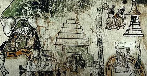
Teoton (center) as it is represented on MC2: not as a mountain but as a huge step pyramid. (Mystery of the Mountain / Groberg Films)
The Map of Cuauhtinchan Number Two
Secreted away in large, wooden, and dusty chest, four ancient Aztec codices were discovered. One of these is the Map of Cuauhtinchan Two (MC2), and surveys an area the size of America’s states of Connecticut and Rhode Island combined - from Teotihuacan in the northwest to Oaxaca in the southeast. Somehow this five-hundred-year-old document survived being destroyed by overzealous Catholic missionaries or acquired by unscrupulous black-market peddlers.
MC2 chronicles a quest beginning in Cholula (site of the world’s largest known pyramid by volume) and ending in the settlement of a city in Cuauhtinchan. The journey depicted is an epic, stylized odyssey guided by gods and demigod heroes, leading the people to build and sanctify temples to the stars, sacred cave structures, and their profound cosmology.
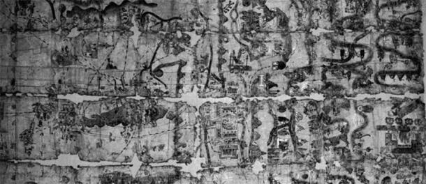
Facsimile of the Cuautinchan II Map, declared a national monument by INAH in 1963. (INAH / CC BY-NC-ND 4.0).
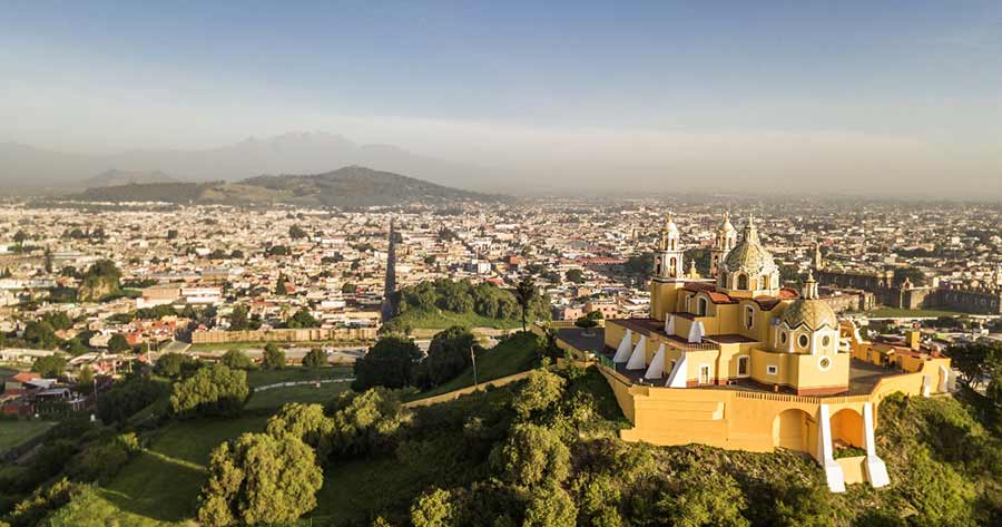
The Pyramid At Cholula
The word cholula itself originates from the Nahuatl word cholollan meaning- “Place of Refuge.” This gargantuan pyramid is closely linked with the Mesoamerican deity Quetzalcoatl and the close by, equally mysterious site of Teotihuacan.
The Aztecs did not build the Cholula Pyramid or Teotihuacan themselves. They inherited them and regarded them as sacred sites of pilgrimage. Dr. James Brady is an archaeologist at California University LA, and based on his interpretation of MC2 together with recent discoveries at Teotihuacan, believes that Cholula was built on top of an aquifer, legitimizing it as a “cosmogram.”
Great Pyramid of Cholula, Puebla, Mexico (background, with church on top) (Diego Delso / CC BY-SA 3.0)
This new concept of celestography means the practice of rendering a space divine/enchanted by erecting structures in harmony with astronomical and geographic features. This is closely related to cosmovision - an attempt to use monuments, landscapes, and civilization to emulate and connect with the unwavering, celestial sphere. Some argue this never existed as a historical practice, and some say it seems to appear all over the prehistoric world.
It is also worth noting that despite the obvious importance to human history, the INAH (Mexico’s National Institute of History and Anthropology) have not conducted or allowed any outside scholars to conduct, any meaningful study or excavation of this site, ostensibly to avoid invasive investigation.
The Giant Builders
According to Aztec mythology, the Quinametzin were a race of giants who inhabited the region in the previous “Sun of Rain” era. These Quinametzin builders allegedly towered over mortal homo sapiens, standing twelve-feet-tall (3.7 meters). The Aztec believed it was they who were responsible for the construction of both Teotihuacan and the Great Pyramid of Cholula.
In the sixteenth century AD, Dominican friar Diego Duran wrote an account that was told to him by an elderly priest of Cholula. This report stated that when the Sun first rose there were giants in the land and that they decided to erect a tower that would ascend up to the Sun. The creator deity was outraged by this, and commanded the inhabitants of the sky to destroy the tower and scatter the arrogant giants.
- Once Hidden in Plain Sight and Surprisingly Ignored: The Great Pyramid of Cholula
- Religion of the Aztecs: Keeping the Balance in an Unpredictable and Terrifying World
Another variation within Aztec mythology is that of seven giants (principle among them Xelhua) who survived a cataclysmic deluge, arrived in the valley, and constructed an artificial, sacred mountain that would prevent another such catastrophe. The deities were furious with this defiance, hurled fire down onto the pyramid, annihilating many of them and ceasing the construction.
Sacred Mountain Aligned With The Stars
The Cholula Pyramid was built precisely equidistant between two volcanic mountains. Popocatepetl, an active, smoldering volcano of destruction, lies to the east. And La Malinche lies to the west, a dormant, lush volcanic mountain, the origin of weather systems, and regarded as extremely sacred.
In this valley, each year between mid-May and July, an astronomical event occurs known as the Zenith Passage. The Zenith Passage is a day in which the Sun rises to directly overhead, casting no shadows. On this day, sunrise occurs in perfect alignment with Cholula (and many other pyramids in corresponding alignment).
Cholula is also aligned in harmonic accordance with a variety of other celestial events, most important of all the fifty-two-year vertical alignment of Orion’s Belt. The Mesoamerican century had a fifty-two-year cycle, as well as a further five days before the “New Fire Ceremony” and the new century would begin.
During this ceremonial period, the Aztecs would abstain from work, fast, make sacrificial blood offerings, destroy household items, and extinguish all fires. Then, on the night of the fifth day, the vertically aligned, three stars of Orion’s Belt would rise in alignment (with Cholula, La Malinche, and Teoton) in what they perceived as a cosmic reset, alighting the world anew.
The first new fire would ignite atop Cholula and then atop the corresponding, sequential pyramids, signifying the rebirth of a new year complete with resolutions, new fires, and new household items.
Orion's belt rising vertically in the night sky aligned with the landmarks and structures. (Mystery of the Mountain / Groberg Films)
La Malinche
Quiet and green, the dormant volcano of La Malinche can often be seen with rings of clouds circling its summit. These clouds then radiate outwards, filling the valley with precious rain-bearing cumulonimbus formations. It is therefore perfectly understandable why inhabitants would revere the mountain and believe that rain emanated from within this holy landmark.
But the sacredness of this mountain goes much deeper. Each year, on the summer solstice, the Sun rises in perfect alignment with the peak of La Malinche. This spectacular alignment is the essential plan for this religious landscape, with so many artificial sacred mountains mimicking the real one.
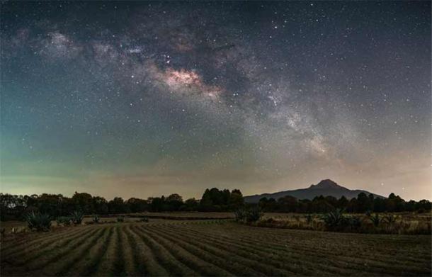
La Malinche in the distance under the starry sky. (Ramon / Adobe Stock)
Sunlight and starlight, whether originating from Orion, the Summer or Winter Solstices, or the Spring/Fall Equinoxes, strike these sacred mountaintops with uncanny precision. Such light also hits a landscape filled with other pyramids, in a zigzag mosaic of celestography, or even astro-polytheistic shamanism.
Around the prehistoric world, cultural diffusion seems to have taken place, spreading this design and with it a powerful sense of religious obligation to build monuments so aligned, to appease and commune with the ancestral star deities.
The Hidden Pyramid At Teoton
As researchers embark on the daunting challenge of inserting the data from MC2 into computer mapping programs, other landmarks are emerging as artificial sacred mountain suspects.
Teoton has long been regarded by locals as an extremely important place, equal to or greater than La Malinche. They recount that the Zenith Passage heralded the beginning of the rainy season, and that this is celebrated by an annual grand feast at the summit of Teoton.
Today, much like Cholula, Teoton resembles a natural mountain; however, on the MC2 map Teoton is represented by a gigantic step pyramid. According to the document, shown to be very accurate in other areas, this pyramid would dwarf even the mighty Pyramid of Cholula.
Also, depicted on the map, beneath the Teoton pyramid, is a sacred cave. These could possibly be the fabled Seven Caves of Chicomoztoc. These supposedly mythological caves are frequently referenced in Mesoamerican creation myths as the place of origin for all Nahuatl-speaking cultures.
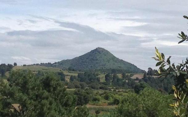
Teoton, Mexico. It now resembles a natural hill, but the pyramid shape is obvious. (Bodofzt / CC BY-SA 4.0)
The Alignments of Teoton
Researchers first suspected Teoton was artificial when they climbed to its peak to do some surveying of their own. They found that Teoton lies on a perfect azimuth with Cholula and all its corresponding alignments. But that was only the beginning of a mind-boggling series of alignments described by the Mystery of the Mountain film.
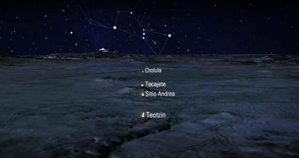
Suffice to say, Teoton resides at a fulcrum point in this intricate series of astronomically aligned structures and natural features. The site is at the equidistant center of four geographic points: the volcano Popocatepetl, the pyramid Apatlaco, the pyramid Montero, and the pyramid Cholula. These four points create an X, with Teoton precisely in the center.
- Ancient Astronomical Alignments: Reading and Mapping the Stars at Early Advanced Civilization Sites
- Was Orion the Heavenly Overlord of Stonehenge?
And let’s not forget, this is all in conjunction with the Zenith Passage, the fifty-two Orion cycle, the Solstices, the Equinoxes, and more.
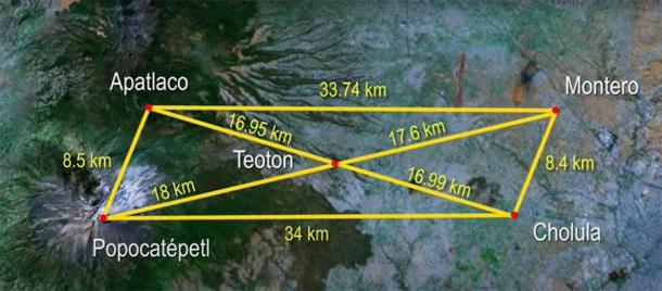
Position of Teoton in relation to other mountains and pyramids in the area. (Mystery of the Mountain / Groberg Films)
Locals who live and farm near Teoton are constantly finding artifacts, including stylized skulls, pottery, figurines, and obsidian daggers and spearheads. Even before the discovery of MC2, for centuries these people have claimed that there is a pyramid hidden within the hill. Besides the never-ending trickle of artifacts, during the rainy season water erosion exposes huge sections of monumental masonry.
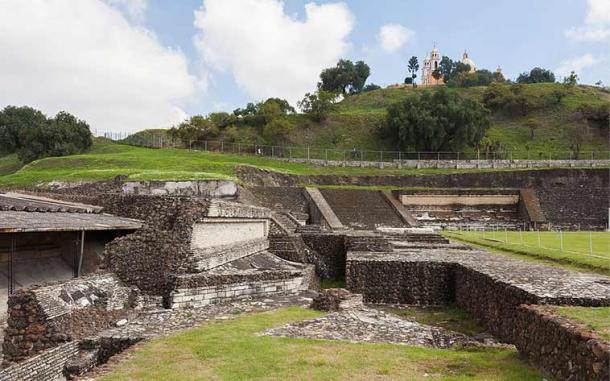
It should be mentioned that the Cholula Pyramid was also a seemingly natural mountain, one we now know contains a giant pyramid. The Cholula Pyramid was said to have been deliberately buried by the natives in ancient times, and some codices depict this as well.
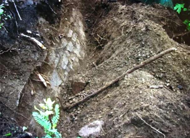
Example of stonework found under the surface of Teoton. (Mystery of the Mountain / Groberg Films)
The Denials of INAH
Despite the fact that Teoton has yielded thousands of artifacts, is aligned to the religious landscape, displays monumental masonry, and looks quite pyramidal in shape, Mexico’s National Institute of Anthropology and History (INAH) opposes the idea that it is a buried pyramid or that there may be any subterranean structure within it. A spokesperson for the INAH, Adriana Saenz stated publicly “while there is evidence the hill was in use, there’s no evidence it is a pyramid.”
Saenz and her superiors do not consider MC2, astronomical alignments, pyramidal shape, and exposed masonry as sufficient evidence. Or perhaps there is another motivation driving their public statements. INAH archaeologists also downplay the cultural significance of the artifacts found at Teoton, stating “because the artifacts were not unearthed by archaeologists, much of the information is lost.”
It is fair to state that some information is lost, but this only relates to dating the artifact (via the soil stratification level). This information is obtainable by comparison of other artifacts, molecular analysis (dependent on material), and the stratification levels of comparable objects.
Although the INAH is critical of the farmers who have been accidently digging up artifacts for decades, there has never been any effort by the institution to cooperate with the farmers to initiate a controlled, ongoing excavation. Whether by lack of focus on the evidence, or whether by design, the INAH have not agreed to investigate the site further.
There are rumors of other sites where investigations are being discouraged. The genetic and laboratory analyses of Pakal the Great and the Red Queen’s bodies remain unpublished, as does their location. The pressurized aqueduct of Palenque, the pyrite sphere and mercury river in the man-made tunnels beneath Teotihuacan, the liquid mercury pools beneath Lamania: these are just a sample of discoveries that are not being objectively studied or sufficiently revealed to the public.
Is Something Being Hidden?
Just last week, it was reported that the INAH reburied an ancient tunnel system adorned by Pre-Columbian glyphs. This massive, artificial tunnel system has been excavated for years, and had been firmly dated by the INAH to around the time of the conquistadors. But then, Pre-Columbian glyphs were discovered. Could the tunnel system be older?
The INAH response was that the laborers simply decorated the tunnel with glyphs copying the ancient style. The glyphs were removed, transported to some museum, and replicas were going to be inserted into the tunnel for tourist attraction purposes.
But none of this was to happen. Suddenly, the INAH announced they would be reburying the entire system, allegedly because of the financial strain imposed on them by the pandemic.
Once artifacts and remains enter into the INAH system, the INAH controls when these will appear in public. They often display replicas instead of the originals. This has been the case with the various masks of Pakal the Great, of which at least half a dozen replicas exist. The original was allegedly stolen and only recovered years later, along with many other key artifacts from Palenque.
Conclusions
One would think that the Mexican authorities would be thrilled at the discovery of a lost pyramid, or at the very least would be motivated to apply their methodology to objectively investigate the matter. Is there any reason for the prehistory of Mexico to be covered up, just as the pyramid is?
For the record, many aspects of the Mexican authorities work very closely and successfully with American and international institutions, like the David Rockefeller Center for Latin American Studies at Harvard University, the Institute of Andean Research (also connected to the Rockefeller Foundation), and UNESCO.
Would these institutions conceal aspects of human history? Or are they all missing the potential for what this site can tell us? Some independent thinkers have enough dots to connect to conclude that a vast network of underground tunnels exists beneath central Mexico, connecting sacred sites. If this is correct, there are potentially many more enormous pyramids yet to be discovered. And put together, these structures, artifacts, and accompanying remains would totally overthrow conventional human history.
Top image: Chulo pyramid view to Popocatepetl. Source: Gian / Adobe Stock
By Mark A. Carpenter
References
Journal of Cultural Geography Landschaft, pueblo and altepetl: a consideration of landscape in sixteenth-century Central Mexico - Scientific Figure on ResearchGate. Available from: https://www.researchgate.net/figure/Glyph-of-Cuauhtinchan-and-Sierra-de-... [accessed 28 Jul, 2021]
Pendergast, David M. (6 August 1982). "Ancient maya mercury". Science. 217 (4559): 533–535
Wake, E. (2007). The Serpent Road: Colonial Iconic Script and the Historical Narrative of Mapa de Cuauhtinchan No. 2. In D. Carrasco (Ed.), The cave, the city, and the eagle's nest: An interpretative journey through the MC2.
Documentary: Mystery of the Mountain: Hidden in Plain View, Groberg Films. 2018. Available from Amazon Prime

Comments
So much of human history is kept secret, conveniently lost, stolen or just plain old destroyed, and for no legitimate reason other than, what?…...
We the sheeple mustn’t know.…
Sad