


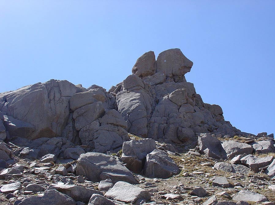
Kuh-e Alvand: Searching for the True Mountain of Noah and his Ark
Kuh-e Alvand is Persian for Mount Alvand. Located in the Zagros mountains near the city of Hamadan in northwestern Iran at map coordinates 34.664167, 48.486667, the elevation of Alvand is 3,580 meters or 11,750 feet, making it one of the tallest mountains in this ancient region.

Credit: Google Maps
The purpose of this article is to provide reasons why Alvand should be considered the modern name and location for ancient Ararat and Aratta—the probable landing site of Noah’s Ark.
Early in the research process, "holy mountains" in Turkey and Iran were used in searches to filter possible locations. The thinking here is that something as important and significant as where Noah's Ark landed and human civilization started (again) would permeate throughout history. Almost every ancient culture maintains a flood legend. In Turkey, both Ararat and Cudi are considered holy mountains. Generally, Bible-believing Christians hold Mount Ararat in Turkey as the traditional landing site of Noah's Ark, while Muslims adhering to the Koran believe that Mount Cudi (pronounced Judi in Turkish) in southern Turkey is the location where Noah's Ark landed. In Iran, both Damavand and Alvand are considered holy mountains.

Credit: Google Maps
Comparing the geography of the four holy mountains, Alvand best fits the description in Genesis 11:2 of people moving “from the east” into Shinar and Sumerian literature describing the location of Aratta.
Tomb of Shem
Near the top of Alvand mountain, there is a local legend that the tomb of Shem is located just below the summit. This would be consistent with the Book of Jubilees that states Noah and Shem stayed on or near the mountain after the Flood. Jubilees also mentions that Noah was buried on the mountain the Ark landed.
The following pictures show what is left of the claimed tomb of Shem. In addition to the stone walls, there are traces of reddish-colored mud bricks that are said to have been used for the top portion in the past.
- Startling Similarity between Hindu Flood Legend of Manu and the Biblical Account of Noah
- The rediscovery of ‘Noah’, a 6,500-year-old skeleton, who survived a Great Flood
- Noah’s Ark to be reconstructed following instructions on ancient Babylonian tablet

Photo by A. Mahdi Ahadian 2015

Photo by A. Mahdi Ahadian 2015
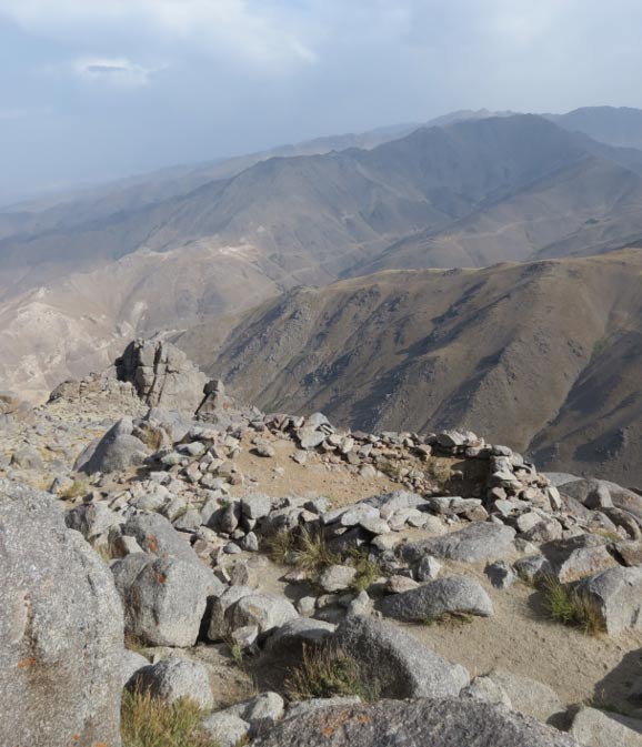
Photo by A. Mahdi Ahadian 2015
Shem’s grave is located approximately 20 meters (65 feet) below the summit rock formation. The tomb dimensions are 5.5 meters (18 feet) by 2.5 meters (8 feet). It appears there was a wall made of stones with the roof made of mud or red clay bricks. Some climbers of Alvand say the roof was destroyed sometime around the 1980’s by treasure hunters, and the stone wall is now shorter. It is common to see a candle lit near Shem’s grave, especially during the summer religious ceremonies in August.

The picture above shows the distance from the edge of Shem’s grave to summit. The Book of Jubilees 10:15 “And Noah slept with his fathers, and was buried on Mount Lubar in the land of Ararat.” In 7:16 it states “And Shem dwelt with his father Noah, and built a city close to his father on the mountain”. A legend of Shem’s grave on the mountain where the Ark landed is just what one would expect from reading the Book of Jubilees. Noah was likely buried in this same tomb or nearby. The legend of Shem’s tomb near the summit of Alvand gives credence that this is the mountain of Noah and where the Ark landed.

- Gun-Yu and the Chinese Flood Myth
- The great Flood through the Sumerian Tablets
- The origins of human beings according to ancient Sumerian texts
Summer religious ceremonies
In addition to the legend of Shem’s tomb near the summit of Alvand, every August there are religious ceremonies near the summit. This ceremony predates the Muslim conversion of Iran. It is interesting that one of the first tasks performed by Noah after exiting the Ark was to build an altar and provide an animal sacrifice.
King James Bible Genesis
8:20-21
And Noah builded an altar unto the LORD; and took of every clean beast, and of every clean fowl, and offered burnt offerings on the altar. 21 And the LORD smelled a sweet savour; and the LORD said in his heart, I will not again curse the ground any more for man's sake; for the imagination of man's heart is evil from his youth; neither will I again smite any more every thing living, as I have done.
The following pictures taken by A. Mahdi Ahadian show the location of the religious ceremonies that still include animal sacrifice. Another picture shows the distance between Shem’s grave and the stone altar for sacrifice.


Having a local legend of Shem’s grave and annual religious ceremonies near the summit of Alvand provide clues this may be the mountain of Noah.
Alvand on ancient caravan route
Hamadan or ancient Ecbatana at the base of Alvand mountain was a key stop on one of the oldest caravan routes connecting Babylon - Susa - Ecbatana. See map below of the ancient near east provided by Bible History Online.

Map credit: Bible History Online
This is an extract from ‘Seven Mountains to Aratta: Searching for Noah’s Ark in Iran’ by B. J. Corbin.
Featured image: The summit of Kuh-e Alvand, northwestern Iran. (Flickr/CC BY-SA 2.0)
By: B. J. Corbin

Comments
Biblical tales are generally allegory for something else and are not to be accepted literally. The flood tale is no different and there are little elements of the flood story that are no more than decoration to give it appearance of reality and one of these is the sacrifice at the end of the flood. This is what would have happened were the tale to be true.
The flood story is probably the best example of allegory as this is a tale of astronomy. It is developed from an India version that is far older than the Biblical tale. Many have noted the similarity between the Biblical version and that added to the Epic of Gilgamesh, the Chaldean version of flood tale. In fact there is not a great deal of similarity to this but much more commonality to the Indian version.
The most important part of the Chaldean interpretation is the location of the landing place of the Ark; this is Mount Nisir or Nizir. This name does not appear on most modern maps and Stapanie Dalley in her 1989 translation of Gilgamesh termed the location Nimush. Earlier translations used Nisir. It should be remembered that the text claims that the Ark landed on the mountains [plural] of Ararat where Ararat is no more than a modern rendering of Urartu, the general region indicated. This is not a precise location unlike the Chaldean version which does tell us where the vessel is to be found.
Igantius Donnelly in his Atlantis investigation used a translation that utilised the name Nizir back in 1882 while the more modern version by John Gardener and John Maier of 1984 translated the word as Nisir. Hence we can be sure that the name Nisir[Nizir or Nazir] is that which applies.
The location is about two miles north of the Iranian border, 10 miles south-east of Dogubayazit, 18 miles south of Greater Mount Ararat and has an elevation approximately 6,300 feet above sea level. There is an old settlement near the site, which has been called Uzengili since the 1950’s, but for thousands of years previously was known as Nisir [Nizir] or Nasar [Nazar]. The name Nisir was changed to Uzengili in the 1950s when an earthquake revealed the ‘vessel’ and has since taken on the title of Durupinar by a number of researchers after the Turkish flyer who spotted the boat shaped formation from the air. Durupinar nonetheless is not the official name of the locality and modern maps including Google Earth name the village Uzengili. Find Uzengili on Google Earth then take a line at 113.24 degrees for a distance of 0.43 of a mile and the centre of the boat shaped rock formation which is described as the vessel of escape from the flood in the Gilgamesh Epic is located. There are numerous photo graphs of the site on Google Earth. The precise location of the centre of this ‘Ark’, an unusual piece of real estate as ascertained by GPS is :-
39 degrees 26.4305 minutes N, 44.degrees14.0795 minutes E.
In Urdu the word Nizir means to present a sacrifice which in fact is what was done by Noah in the story, at the end of the period in the Ark. In fact the dimensions of this geological anomaly are confirmed as corresponding to the Genesis account. This is explained in the book described below.
So we have the correct location according to the Chaldean version and a correspondence via the location name and dimensions of the ‘boat’with the Biblical tale.
So our article author need search no more…this is the Ark location as long accepted by the locals of the region. This was added to a tale of a flood that in fact was a heavenly flood and not a deluge on Earth. Did not the Egyptian Ra, the sun, require a boat to traverse the skies? Do we not we see a similarity to Veruna an Indian deity who travelled in his vessel in the skies? I find it a bit of puzzle that Genesis 1: 6-9 can describe an ocean in the skies and then be ignored by flood researchers because this must be one of the most important statements in the whole Bible. It tells us that all is not what it seems. In fact in Genesis there are two versions of the flood tale that many researchers claim have different authors [possible] and are not really connected [not true, they are].
The flood, in reality, is a cyclic affair and refers to the loss of a pole star. This parallels the falling of the ‘Pillars of Heaven’ in the Chinese version of the tale. Plato used the same scenario in his Atlantis story referring to the constellation Hercules with his statements regarding the Pillars of Hercules; Plato’s Hercules was the heavenly constellation of that name that held the pole star of the era 8100BC to 9000BC . He was referring to a date and not a location at the entry to the Mediterranean from the Atlantic. This has implications for Biblical dating regarding the end of the flood because it last a ‘godly’ year of 3600 years. This is a canonical value as no pole star[or flood periods] vary but creation eras are consistently of 1000 years. This is all made clear in the Indian narratives. The next creation era was when Thuban in Draconis took over at 3300BC and remained pole star until 2300BC. There is much that has been completely misunderstood regarding such stories from the distant past and they require evaluating completely differently to modern historical events.
The book Deluge:From Genesis to Atlantis reveals all and is available to download free or read online at https://independent.academia.edu/HarrySivertsen
This is a work that including the numerous reference listings is over 500 pages in length. It covers a wide area but all subject areas are part of the argument and analysis involved in solving the puzzle of the floods of the religious works and Plato’s Atlantis.
Research for this work commenced in the mid 1980s and the book was completed circa 2010 and indeed has had a few updates since. It has been praised for its analytical worth and explanations by a number of readers. There is much that is seen to be astronomical in nature and the easiest clues to start such an investigation emerge from India. Readers who are interested in the truth of these matters may also note the paper Ancient Indian Calendars on the same web page as Deluge:From Genesis to Atlantis. This paper is enlightening regarding dating and among many associations shows the use of climatic events as points of reference that are verifiable via modern ice core research. We push the boundaries of intelligent recording of events back considerably…with powerful evidence that it would be difficult if not impossible to counter.
Harry Sivertsen
Hi Saratok,
You asked me who ows the language in which the word ``Ararat`` means ``sacred land or high land``?
The following is a good explication of the meaning of the word Ararat:
It is believed that the land of “Ararat” is the Hebrew equivalent of Urardhu, or Urartu, which was the Assyrian-Babylonian name of the Vannic or Chaldean kingdom (between the Aras River and the Tigris River).
This part of Armenia was inhabited by a people who spoke a language unlike any other now known, though it may have been related to the modern Georgian.
About B.C., 900 they borrowed the cuneiform characters of Nineveh, and from this time we have inscriptions of a line of kings who at times contended with Assyria.
At the close of the seventh century B.C. the kingdom of Ararat came to an end, and the country was occupied by a people who are ancestors of the Armenians of the present day.
I hope this explication may help you.
Blessings.
“Ararat: sacred land or high land”
Excuse me, could you tell me who owns the language in which the word "Ararat" means "sacred land or high land"?
Hi everyone. Some of the comments in the blog are about Noah`s ark, so i`m going to post a new that i was reading in an article, a time ago. This article was concerning to the current situation of glaciers in an area from Mount Ararat. In this area the ice and snow has been slipping so that is no longer the same as it was some years ago. Much of this mass of snow and ice has moved causing glaciers to change the old position that they had in previous years. This change in the position of glaciers affects an area of the mountain that is considered by many as the final resting place of Noah`s ark. A large object is in this place, but most of the time covered by snow and ice, and it is likely that this change in glaciers affects the current position of this object in the mountain.
Hi Mic, Although it has been a time since you have posted this comment, I would like to add something about what you were saying regarding to Davis`s statement: that the village was "built into the mountain side" and that the houses of that village looked like "favelas". Well, not everything in Davis`s story is too clear as we would like it to be, but although Davis talked about this, it seems that the mountain was not really near to Abas-Abas`s home. This could be, because Davis stated that they left Abas-Abas home sometime around midnight, and they drove in a truck until the next morning, at dawn, so if Abas`s house was next to the mountain, why they had to drive for so many time to get to the mountain? This is a very interesting question.
Pages