Embarking on a voyage that bridges time and tradition, modern-day adventurers pay homage to the ancient Polynesian voyagers who first discovered the remote Hawaiian islands . Guided by the celestial...
We all know that the compass is an invaluable tool for navigation and orientation. Without it, we’d pretty much be “lost at sea”. That’s why it ranks as one of the most important inventions of...
Neolithic stone balls are mysterious petrospheres found in Scotland, Ireland, and Norway that have puzzled archaeologists for centuries. But an explanation for these objects may finally be revealed,...
The Polynesian peoples have long been known as incredibly skilled sailors, and have navigated the vast and seemingly empty expanse of ocean - in search of new islands to settle. This they did with...
Minoan civilization may have been heavily dependent on celestial star paths up above to help them navigate their way throughout the Mediterranean. A study has found that Minoan palaces were even...
The Earth is a big place, and it has taken us a long, long time to fully map it. Today, it is easy to feel like the last of the great adventures is over, and we’ve found all that there is to be found...
In 2012, a team of divers in Spain discovered two 16th century cannons, and that was huge news. But nobody could have dreamed that an ancient astronomical compass, known as an astrolabe, would...
A team of German and Spanish researchers has published a new computational model demonstrating how Pleistocene hominins crossed the sea and sea straits between one and two million years ago...
Charles H. Hapgood began his book, Maps of the Ancient Sea Kings , by stating, after studying composite maps at least partially derived from ancient sources, that ancient voyagers traveled from pole...
It was a few years ago that a Greek-American archaeological team made a startling discovery – they found the oldest indications of seafaring and navigation in the world, in an area called Plakia on...
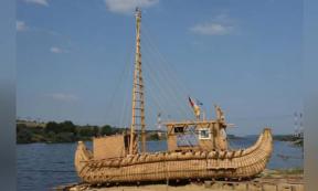
Described by the New York Times as “part P. T. Barnum and part Indiana Jones” an eccentric former German school teacher, Dominique Goerlitz, has told reporters at AFP that he has assembled a team of...
How do human foragers find food or the way home in rainforests, where heavy vegetation limits visibility, without a map, compass, or smartphone? Researchers at the Max Planck Institute for...
A brave Japanese and Taiwanese rowing team has successfully replicated a 32,000-year-old ancient sea migration route in a traditional dugout canoe. After two failed attempts on Sunday afternoon, one...
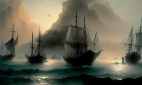
The Vikings have been reputed to be remarkable seafarers who could fearlessly navigate their way through unknown oceans to invade unsuspecting communities along the North Sea and Atlantic Sea coasts...
Were our primeval ancestors skilled mariners who sailed thousand of miles to distant islands using language, or did they grunt at each other while holding onto tree trunks being blown randomly on the...
Details of the earliest known marine navigation tool, discovered in a shipwreck, have been revealed thanks to state-of-the-art scanning technology at WMG, University of Warwick. Professor Mark...
For 1,000 years, the mysterious origin of the Druze people – who live almost exclusively in the mountains of Syria, Lebanon and Israel – has captivated linguists, historians, and sociologists. There...
Controversy surrounds the knowledge the Portuguese had about Brazil before they entered into the Treaty of Tordesillas. The Treaty of Tordesillas, signed in 1494, was a treaty between Castile (Spain...
People were navigating long distances between islands in the Pacific for at least 2,000 years. How did they do it without astrolabes, sextants or modern satellite positioning technology? One group,...
Ancient Origins Guest Writer, William James Veall, is far afield from his usual research concerning Trans-Oceanic visitations to South America. On this occasion he turns his attention towards the...
History is a record of the past – sculptured by omissions, interlarded with distortions, brazen lies and innocent befuddlement – forming an amalgam that's often stubbornly resistant to analysis. For...
Songlines (known also as dreaming tracks) are believed by the Aboriginal people of Australia to be the journeys taken by the creation ancestors (or creator-beings) across the land during the Dreaming...
By Stephen Harding Ancient records tell us that the intrepid Viking seafarers who discovered Iceland, Greenland and eventually North America navigated using landmarks, birds and whales, and little...
The Vikings have been reputed to be remarkable seafarers who would confidently head into unexplored waters. Now a team of researchers from Hungary and Sweden claim to have a clue as to how the Norse...