


The Cataclysm of Easter Island - And the Statues Walked… (Part 3)
Easter Island may have been first discovered over 5,000 years ago, though the oldest carbon dating is from about 300 AD. Most sites are near the ocean and would have been washed and destroyed by waves over the many hundreds and thousands of years that man may have been on the island. Did a cataclysm tidal wave bury the statues in mud and muck around 300 AD? It is known that Polynesia was settled many thousands of years before this—humans have been on Tonga since before 1000 BC according to the dating of Lapita pottery found there.
In his fascinating book, Mysteries of Easter Island, Francis Mazier explores the legends of the statues and the lost land of Hiva. Mazier was able to talk with a dying leper named Gabriel Veriveri who was allegedly the last initiate of the secrets of Easter Island. Said Veriveri to Maziere, “King Hotu-Matua came to Easter Island in two canoes. He landed at Hangaroa, but he gave the bay the name of Anakena, because it was the month of July.” He notes that the winds from Polynesia to Easter Island blow in July and August.
“King Hotu-Matua’s country was called Maori (in the Maori dialect of New Zealand, the word maori means “ordinary people”), and it was on the continent of Hiva. The place where he lived was called Marae-Rena... the king saw that the land was slowly sinking in the sea. The king therefore called all his people together, men, women, children and the aged, and he put them into two great canoes. The king saw that the disaster was at hand, and when the two canoes had reached the horizon he observed that the whole of the land had sunk, except for a small part called Maori.”
Says Maziere:
The tradition is clear: there was a cataclysm; and it appears that this continent lay in the vast hinterland that reaches to the Tuamotu archipelago (what is largely today French Polynesia) to the north-west of Easter Island.
Another legend, handed on by Aure Auviri Porotu, the last of the island’s learned men, says this: ‘Easter Island was a much larger country, but because of the sins of its people Uoke tipped it up and broke it with a crowbar...’ Here too we have a cataclysm.
A more important point is that according to tradition Sala-y-Gomez, an islet some hundred miles from Easter Island, was formerly part of it, and its name, Motu Motiro Hiva, means ‘small island near Hiva’.
We have three signs pointing to this cataclysm. Yet generally accepted geology does not acknowledge any vast upheaval in this part of the world, at least not within the period of human existence. However, there are two recently discovered facts that make the possibility of a sunken continent seem reasonable. When the American submarine Nautilus made her voyage round the world she called attention to the presence of an exceedingly lofty and still unidentified underwater peak close to Easter Island. And secondly, during his recent studies carried out for the Institute of Marine Resources and the University of California, Professor H.W. Menard not only speaks of an exceedingly important fracture-zone in the neighbourhood of Easter Island, a zone parallel to that of the Marquesas archipelago, but also of the discovery of an immense bank or ridge of sediment.

Maziere’s book came out in 1965 in France, four years before the revolutionary geological theory of tectonic plates changed geology forever. It was certainly true then, and seemingly so today, that geologists generally do not acknowledge a cataclysmic upheaval (or downheaval as the case may be!) in this part of the world. Yet, Maziere sought to make sense out of the legends of the Easter Islanders. Were they just talk? Traditional anthropologists typically ignored the natives’ own legends, and said that they came by way of Tahiti, possibly after some war, a few hundred years before Europeans first visited them. Such mysteries as rongorongo writing and the incredible stone platform at Vinapu are ignored.
Maziere favored the existence of an archipelago and even a long, thin “continent” extending south and north of Easter Island between the Marquesas Islands and the Galapagos Islands. Easter Island was the last peak (along with Sala-y-Gomez) of this former continent not “wrent beneath the sea by Uoke’s crowbar.”
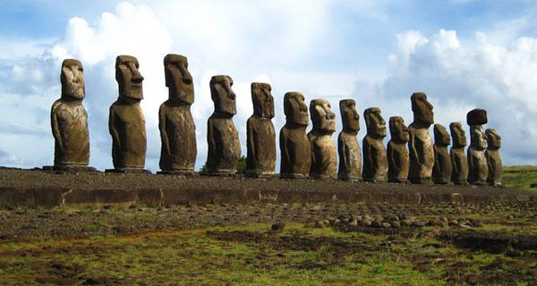
Apart from preserving the memory of these upheavals, tradition also states that King Hotu-Matua came from the west. Now in Easter Island on the Ahu A’Tiu there are seven statues and they are the only ones on the island that look towards the sea, and more exactly, the western sea. Their precise placing might well fix the area of the cataclysm, which would thus lie between the Marquesas and the Gambier islands. It seems probable that during one of those sub-oceanic upheavals still so frequent in the zone between the Cordillera of the Andes and the New Hebrides, an archipelago—I do not presume to say a continent—may have sunk or been altered. Moreover, according to Professor Metraux’s findings, it seems possible that King Hotu-Matua’s men emigrated from this area of the Marquesas; the reasons for believing this are based on linguistics—the use of Hiva is an example—and many points of ethnological agreement. The date of this migration, according to the genealogies that we collected, would be towards the end of the twelfth century.
This settlement in no way excludes the possibility of other contacts at far earlier periods—contacts that we shall speak of later.
Maziere then goes on to discuss the legend of seven explorers first sent out to find “the navel of the world” and then to return and guide the two giant canoes to safety on Rapa Nui. He finds it odd that in the Marquesas, where some of the islands actually have the name of Hiva in them, there is really no legend of a sunken continent. He then says that the footless, handless old leper Veriveri told him of a legend he had learned that the island was inhabited already when Hotu-Matua came by “very big men, but not giants, who lived on the island well before the coming of Hotu-Matua.”
It seems very clear to me that this is a legend, based on a great deal of analogy and mythos. It also seems to have some basis in fact. There is one level of Hiva being an allegory for a spirit world where one goes upon transition, much as that of Hawaiki. On the other hand, the legend seems to be of a physical place, an ancient homeland that went down in a catastrophe. Is this event then the actual sinking of some island mass many thousands of years ago? Or, rather, is it the final subsidence, perhaps only a few thousand years ago, of the last large area that remained above the surface? Maziere seems to think that the last remnants of this land, called Davis Land, sank as late as the 1600s. In his book he proposed a long landmass that stretched from Easter Island to the Baha California Peninsula in Mexico.
Part 4 - Stones walking
Part 5 - The Megalithic Wall of Vinapu
Part 6: The Museum in Hanga Roa
